Geolocate

Kjelfossen topographic map

Click on the map to display elevation.

About this map

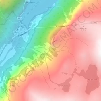
Name: Kjelfossen topographic map, elevation, terrain.

Location: Kjelfossen, Gudvangen, Aurland, Vestland, 5747, Norway (60.87406 6.85773 60.87416 6.85783)

Average elevation: 762 m

Minimum elevation: 0 m

Maximum elevation: 1,441 m

Other topographic maps

Click on a map to view its topography, its elevation and its terrain.

Nærøyfjorden

Norway > Vestland > Gudvangen

Average elevation: 932 m

Gear up for your next adventure:

🛌Insulated Sleeping Pad - Critical thermal barrier between you and the cold ground
🛶Waterproof Dry Bags - Keep electronics and clothes dry during river crossings
🔨Vehicle Emergency Tool - Safety tool for remote road trips to trailheads
🥾Trail Running Boots - Durable shoes designed for trail running
🧭Orienteering Kit - Tools for map reading and navigation in the wild

As an Amazon Associate, this site earns from qualifying purchases at no extra cost to you.