Geolocate

Oppland topographic map

Click on the map to display elevation.

About this map

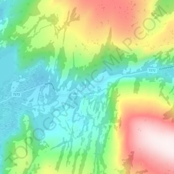
Name: Oppland topographic map, elevation, terrain.

Location: Oppland, Vefsn, Nordland, 8666, Norway (65.88031 12.78699 65.92031 12.82699)

Average elevation: 299 m

Minimum elevation: 56 m

Maximum elevation: 756 m

Other topographic maps

Click on a map to view its topography, its elevation and its terrain.

Saltdal

Norway > Nordland

Average elevation: 738 m

Hadsel

Norway > Nordland

Average elevation: 101 m

Værøy

Norway > Nordland

Average elevation: 3 m

Narvik

Norway > Nordland

Average elevation: 509 m

Hattfjelldal

Norway > Nordland

Average elevation: 688 m

Gear up for your next adventure:

🥾Hiking Leggings - Comfortable leggings for outdoor activities
🌡️Emergency Mylar Blankets - Compact thermal protection for unexpected nights outdoors
🥾All-Terrain Hiking Boots - Versatile boots for varied hiking conditions
💡LED Camping Lantern - Illuminate your campsite with long-lasting lanterns
🥾Approach Boots - Comfortable boots for hiking and climbing approaches

As an Amazon Associate, this site earns from qualifying purchases at no extra cost to you.