Geolocate

Dølemo topographic map

Click on the map to display elevation.

About this map

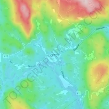
Name: Dølemo topographic map, elevation, terrain.

Location: Dølemo, Åmli, Agder, Norway (58.69245 8.32345 58.73245 8.36345)

Average elevation: 254 m

Minimum elevation: 165 m

Maximum elevation: 476 m

Other topographic maps

Click on a map to view its topography, its elevation and its terrain.

Tvedestrand

Norway > Agder

Average elevation: 75 m

Lygna

Norway > Agder

Average elevation: 273 m

Kristiansand

Norway > Agder

Average elevation: 76 m

Gear up for your next adventure:

🥾Hiking Leggings - Comfortable leggings for outdoor activities
🧢Hiking Hat - Sun-protective and breathable hats for long treks
🦶Hiking Shoe Insoles - Added support for high arches and long days on feet
🎒Backpack Rain Cover - External shield to keep your entire pack dry
❄️Traction Ice Cleats - Slip-on spikes for icy trails and winter hiking

As an Amazon Associate, this site earns from qualifying purchases at no extra cost to you.