Geolocate

Vanse topographic map

Click on the map to display elevation.

About this map

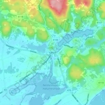
Name: Vanse topographic map, elevation, terrain.

Location: Vanse, Farsund, Agder, 4560, Norway (58.07815 6.67127 58.11815 6.71127)

Average elevation: 28 m

Minimum elevation: -2 m

Maximum elevation: 138 m

Gear up for your next adventure:

🥾Mountain Hiking Boots - High-traction boots for rocky terrain
🥾Trail Running Boots - Durable shoes designed for trail running
🔪Outdoor Multitool - Versatile tool for repairs and food prep in the wild
🧴Waterproofing Spray - Restore the DWR coating on jackets and tents
🚑Survival Whistle - Signal for help across long distances in mountains

As an Amazon Associate, this site earns from qualifying purchases at no extra cost to you.