Geolocate

Bolten topographic map

Click on the map to display elevation.

About this map

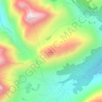
Name: Bolten topographic map, elevation, terrain.

Location: Bolten, Stranda, Møre og Romsdal, Norway (62.23625 6.75354 62.23635 6.75364)

Average elevation: 859 m

Minimum elevation: 555 m

Maximum elevation: 1,336 m

Other topographic maps

Click on a map to view its topography, its elevation and its terrain.

Tingvoll

Norway > Møre og Romsdal

Average elevation: 199 m

Molde

Norway > Møre og Romsdal

Average elevation: 712 m

Gear up for your next adventure:

🥾Hiking Boots - Sturdy boots providing ankle support and traction on rugged trails
🧢Hiking Hat - Sun-protective and breathable hats for long treks
🥫Freeze-Dried Meals - Lightweight, high-calorie nutrition for multi-day treks
🐕Hiking Dog Pack - Let your canine companion carry their own water and food
🧦Crew Hiking Socks - Comfortable socks for long-distance hikes

As an Amazon Associate, this site earns from qualifying purchases at no extra cost to you.