Geolocate

Lygna topographic map

Click on the map to display elevation.

About this map

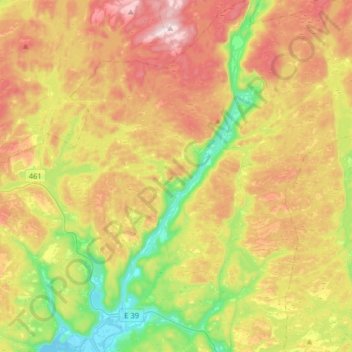
Name: Lygna topographic map, elevation, terrain.

Location: Lygna, Agder, Norway (58.13953 7.04952 58.30889 7.21321)

Average elevation: 273 m

Minimum elevation: -4 m

Maximum elevation: 603 m

Other topographic maps

Click on a map to view its topography, its elevation and its terrain.

Tvedestrand

Norway > Agder

Average elevation: 75 m

Ausland

Norway > Agder > Gjerstad

Average elevation: 127 m

Dølemo

Norway > Agder

Average elevation: 254 m

Mandal

Norway > Agder

Average elevation: 38 m

Vanse

Norway > Agder > Farsund > Vanse

Average elevation: 28 m

Kristiansand

Norway > Agder

Average elevation: 76 m

Hovden

Norway > Agder

Average elevation: 875 m

Kvåfjord

Norway > Agder

Average elevation: 53 m

Gear up for your next adventure:

💧Filtered Water Bottle - Safe drinking water on the go
🔋Lithium AA Batteries - Long-lasting power that performs in extreme cold
🧭GPS Outdoor Watch - Smart watch for navigation and fitness tracking in nature
🧦Hiking Liner Socks - Thin base layer to prevent friction and blisters
🦯Trekking Poles - Reduced impact on joints for steep topographic climbs

As an Amazon Associate, this site earns from qualifying purchases at no extra cost to you.