Geolocate

Molden topographic map

Click on the map to display elevation.

About this map

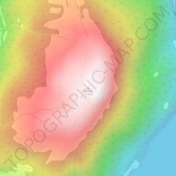
Name: Molden topographic map, elevation, terrain.

Location: Molden, Luster, Vestland, 6870, Norway (61.34510 7.31627 61.34520 7.31637)

Average elevation: 618 m

Minimum elevation: 0 m

Maximum elevation: 1,116 m

Other topographic maps

Click on a map to view its topography, its elevation and its terrain.

Fitjar

Norway > Vestland

Average elevation: 92 m

Gisøya

Norway > Vestland

Average elevation: 14 m

Etne

Norway > Vestland

Average elevation: 703 m

Nærøyfjorden

Norway > Vestland > Gudvangen

Average elevation: 932 m

Høyanger

Norway > Vestland

Average elevation: 528 m

Eidfjord

Norway > Vestland > Eidfjord

Average elevation: 494 m

Gear up for your next adventure:

🧭GPS Handheld Device - Reliable GPS navigation for outdoor adventures
🔦UV Flashlight - Detect minerals or specific insects in the dark
🧥Thermal Fleece Jacket - Versatile insulation for changing mountain temperatures
🚲Handlebar Phone Mount - View topographic-map.com live while cycling
🧤Insulated Winter Gloves - Heavy-duty protection for sub-zero Canadian adventures

As an Amazon Associate, this site earns from qualifying purchases at no extra cost to you.