Geolocate

Rysjedal topographic map

Click on the map to display elevation.

About this map

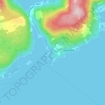
Name: Rysjedal topographic map, elevation, terrain.

Location: Rysjedal, Hyllestad, Vestland, Norway (61.09409 5.26686 61.13409 5.30686)

Average elevation: 61 m

Minimum elevation: 0 m

Maximum elevation: 342 m

Other topographic maps

Click on a map to view its topography, its elevation and its terrain.

Fitjar

Norway > Vestland

Average elevation: 92 m

Gisøya

Norway > Vestland

Average elevation: 14 m

Etne

Norway > Vestland

Average elevation: 703 m

Nærøyfjorden

Norway > Vestland > Gudvangen

Average elevation: 932 m

Eidfjord

Norway > Vestland > Eidfjord

Average elevation: 494 m

Høyanger

Norway > Vestland

Average elevation: 528 m

Gear up for your next adventure:

🧊Portable Cooler - Keep food and drinks cold during outdoor adventures
💧Hydration Bladder - Hands-free hydration solution for long treks
🕶️Polarized Sunglasses - Protect your eyes with durable polarized lenses
🥾Waterproof Hiking Shoes - Durable shoes for wet and rugged trails
🔋Emergency Crank Radio - Weather alerts and power without needing batteries

As an Amazon Associate, this site earns from qualifying purchases at no extra cost to you.