Geolocate

Lysebotn topographic map

Click on the map to display elevation.

About this map

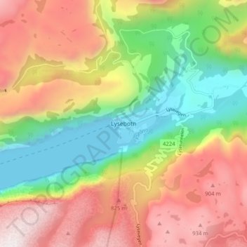
Name: Lysebotn topographic map, elevation, terrain.

Location: Lysebotn, Sandnes, Rogaland, 4127, Norway (59.03478 6.62687 59.07478 6.66687)

Average elevation: 500 m

Minimum elevation: -6 m

Maximum elevation: 1,060 m

Gear up for your next adventure:

🧦Merino Wool Socks - Moisture-wicking comfort for long-distance hiking
🥾Trail Running Shoes - Lightweight and durable shoes for trail running
🥾Hiking Shoes - Durable and comfortable shoes for trail hiking
🧢Outdoor Visor - Breathable visor for sunny hikes
🔦LED Headlamp - Hands-free lighting for early morning starts or late finishes

As an Amazon Associate, this site earns from qualifying purchases at no extra cost to you.