Geolocate

Straumen topographic map

Click on the map to display elevation.

About this map

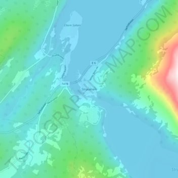
Name: Straumen topographic map, elevation, terrain.

Location: Straumen, Sørfold, Nordland, 8226, Norway (67.32843 15.57681 67.36843 15.61681)

Average elevation: 94 m

Minimum elevation: -1 m

Maximum elevation: 682 m

Other topographic maps

Click on a map to view its topography, its elevation and its terrain.

Saltdal

Norway > Nordland

Average elevation: 738 m

Hadsel

Norway > Nordland

Average elevation: 101 m

Narvik

Norway > Nordland

Average elevation: 509 m

Værøy

Norway > Nordland

Average elevation: 3 m

Hattfjelldal

Norway > Nordland

Average elevation: 688 m

Gear up for your next adventure:

🔭Outdoor Binoculars - Lightweight binoculars for birdwatching and hiking
🦶Anti-Blister Balm - Prevents friction and hotspots during long ascents
🦟Insect Repellent - Keep mosquitoes and black flies away in wooded areas
🧊Portable Cooler - Keep food and drinks cold during outdoor adventures
🕶️Polarized Sunglasses - Protect your eyes with durable polarized lenses

As an Amazon Associate, this site earns from qualifying purchases at no extra cost to you.