Geolocate

Jimmy Lake topographic map

Click on the map to display elevation.

About this map

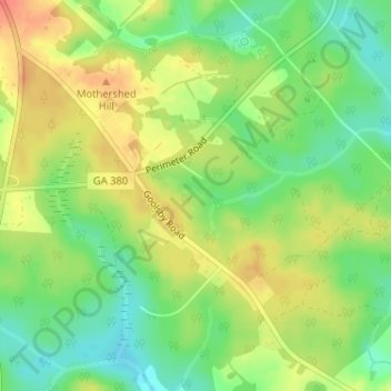
Name: Jimmy Lake topographic map, elevation, terrain.

Location: Jimmy Lake, Jasper County, Georgia, United States (33.27063 -83.65956 33.27171 -83.65761)

Average elevation: 183 m

Minimum elevation: 159 m

Maximum elevation: 206 m

Other topographic maps

Click on a map to view its topography, its elevation and its terrain.

Waleska

United States > Georgia > Cherokee County

Average elevation: 335 m

McCaysville

United States > Georgia > Fannin County

McCaysville's weather is temperate due to its elevation and location in the southern Appalachians. Summers are warm with average highs in the middle 80s and lows in the lower 60s. Winters are cool with average highs in the 40s and average lows in the 20s. Rainfall is abundant with the yearly average…

Average elevation: 484 m

Young Harris

United States > Georgia > Towns County

Average elevation: 606 m

Habersham County

United States > Georgia

The highest point in the county is a 4,400-foot (1,300 m) knob less than 700 feet (210 m) southeast of the top of Tray Mountain, the seventh-highest mountain in Georgia. Habersham shares this portion of Tray Mountain, just 30 vertical feet shy of the peak's 4,430-foot summit, with White County to the west and…

Average elevation: 448 m

Houston County

United States > Georgia

Average elevation: 111 m

Bloomingdale

United States > Georgia > Chatham County

Average elevation: 8 m

Tifton

United States > Georgia > Tift County

Average elevation: 104 m

Marietta

United States > Georgia > Cobb County

Average elevation: 323 m

Decatur

United States > Georgia > DeKalb County

Average elevation: 308 m

Bleckley County

United States > Georgia

Average elevation: 104 m

Conyers

United States > Georgia > Rockdale County

Average elevation: 251 m

Valdosta

United States > Georgia > Lowndes County

Average elevation: 58 m

Snellville

United States > Georgia > Gwinnett County

Compared to most large cities around the world at approximately the same latitude (33°39'), such as Beirut, Casablanca, Dallas, Los Angeles, and Phoenix, Snellville has lower average winter temperatures. The primary reason for this is that the North American continent extends into high latitudes that allows…

Average elevation: 300 m

Hancock County

United States > Georgia

Average elevation: 143 m

Woodbine

United States > Georgia > Camden County

Average elevation: 6 m

Holly Springs

United States > Georgia > Cherokee County

Average elevation: 306 m

Toombs County

United States > Georgia

Average elevation: 57 m

Bonaire

United States > Georgia > Houston County

Average elevation: 100 m

Spalding County

United States > Georgia

Average elevation: 247 m

Kingsland

United States > Georgia > Camden County

Average elevation: 5 m

Helen

United States > Georgia > White County

Average elevation: 488 m

Adel

United States > Georgia > Cook County

Average elevation: 72 m

Brasstown Bald

United States > Georgia > Towns County

Average elevation: 1,161 m

Powder Springs

United States > Georgia > Cobb County

Average elevation: 291 m

Lowndes County

United States > Georgia

Average elevation: 52 m

Rossville

United States > Georgia > Walker County

Average elevation: 251 m

Glynn County

United States > Georgia

Average elevation: 4 m

Dodge County

United States > Georgia

The Heart of Georgia Regional Airport is located three miles east of Eastman off of State Route 46. Elevation 304'. Runway 02/20 is 6,506'x100'and has a precision instrument landing system. The airport is owned by the Heart of Georgia Regional Airport Authority and is home to the Middle Georgia State College…

Average elevation: 84 m

Whitfield County

United States > Georgia

Average elevation: 258 m

Bulloch County

United States > Georgia

Average elevation: 48 m

Cherokee Hills

United States > Georgia > Coffee County

Average elevation: 70 m

Webster County

United States > Georgia

Average elevation: 146 m

Jackson County

United States > Georgia

Average elevation: 253 m

Leesburg

United States > Georgia > Lee County

Average elevation: 76 m

Forbes Lake

United States > Georgia > Macon County

Average elevation: 126 m

Bainbridge

United States > Georgia > Decatur County

Average elevation: 37 m

Baxley

United States > Georgia > Appling County

Average elevation: 61 m

Atlanta

United States > Georgia > Fulton County

Atlanta (/ætˈlæntə/ at-LAN-tə) is the capital and most populous city of the U.S. state of Georgia. It is the seat of Fulton County, the most populous county in Georgia, but its territory falls in both Fulton and DeKalb counties. With a population of 498,715 living within the city limits, it is the eighth…

Average elevation: 285 m

Newnan

United States > Georgia > Coweta County

Average elevation: 272 m

High Hill Lake

United States > Georgia > Glynn County

Average elevation: 7 m

Elbert County

United States > Georgia

Average elevation: 177 m

Hiram

United States > Georgia > Paulding County

Average elevation: 306 m

Keith

United States > Georgia > Catoosa County > Keith

Average elevation: 267 m

Johns Creek

United States > Georgia > Fulton County > Johns Creek

Average elevation: 305 m

Ware County

United States > Georgia

Average elevation: 42 m

Oglethorpe County

United States > Georgia

Average elevation: 186 m

Jackson

United States > Georgia > Jackson

Average elevation: 203 m

Peachtree City

United States > Georgia > Fayette County

Shakerag Hill, with an elevation of 980 feet (300 m), is the highest point in the city and sits on the eastern border at the intersection of GA Hwy 54 and Robinson Road.

Average elevation: 263 m

Americus

United States > Georgia > Sumter County > Americus

Average elevation: 125 m

Dublin

United States > Georgia > Laurens County > Dublin

Average elevation: 68 m

Sautee

United States > Georgia > Sautee

Average elevation: 441 m

Burwell

United States > Georgia > Burwell

Average elevation: 333 m

Swainsboro

United States > Georgia > Emanuel County > Swainsboro

Average elevation: 83 m

Fairburn

United States > Georgia > Fulton County > Fairburn

Average elevation: 293 m

Braselton

United States > Georgia > Jackson County

Average elevation: 268 m

Liberty County

United States > Georgia > Liberty County

Average elevation: 12 m

Fort McPherson

United States > Georgia > Fulton County > Atlanta

Average elevation: 309 m

Tifton

United States > Georgia > Tift County > Tifton > Tifton

Average elevation: 96 m

Rincon

United States > Georgia > Effingham County > Rincon

Average elevation: 19 m

Terrell County

United States > Georgia > Terrell County

Average elevation: 103 m

Wolf Island

United States > Georgia > McIntosh County

Average elevation: 0 m

Dade County

United States > Georgia

Average elevation: 382 m

Saint Marys River

United States > Georgia

Average elevation: 24 m

Carrollton

United States > Georgia > Carroll County > Carrollton

Average elevation: 329 m

Albany

United States > Georgia > Dougherty County > Albany > Albany

Average elevation: 70 m

Fairmount

United States > Georgia > Gordon County > Fairmount

Average elevation: 247 m

Shellnut

United States > Georgia > Heard County > Shellnut

Average elevation: 235 m

Winder

United States > Georgia > Barrow County > Winder

Average elevation: 274 m

Chelsea

United States > Georgia > Chattooga County > Chelsea

Average elevation: 269 m

Dunwoody

United States > Georgia > DeKalb County

Average elevation: 313 m

Long Lake

United States > Georgia > Charlton County

Average elevation: 38 m

Murray County

United States > Georgia

Average elevation: 381 m

Lucile

United States > Georgia > Miller County

Average elevation: 65 m

Douglasville

United States > Georgia > Douglas County

Located along a natural rise in the topography, Douglasville was originally known as "Skint Chestnut."[6] The name was derived from a large tree used by Native Americans as a landmark; it was stripped of its bark so as to be more conspicuous.

Average elevation: 310 m

Commerce

United States > Georgia > Jackson County

Average elevation: 252 m

Hall County

United States > Georgia

Average elevation: 339 m

Camden County

United States > Georgia

Average elevation: 4 m

Bonair

United States > Georgia > Richmond County > Augusta

Average elevation: 84 m

Cook County

United States > Georgia

Average elevation: 72 m

Colquitt County

United States > Georgia

Average elevation: 85 m

Gear up for your next adventure:

🦟Insect Repellent - Keep mosquitoes and black flies away in wooded areas
💧Filtered Water Bottle - Safe drinking water on the go
🧴Waterproofing Spray - Restore the DWR coating on jackets and tents
🔪Outdoor Multitool - Versatile tool for repairs and food prep in the wild
Family Camping Tent - Spacious tent suitable for family camping trips

As an Amazon Associate, this site earns from qualifying purchases at no extra cost to you.