
Make a donation
Gear up for your next adventure:
As an Amazon Associate, this site earns from qualifying purchases at no extra cost to you.
McCaysville topographic map
Click on the map to display elevation.
Make a donation
Gear up for your next adventure:
As an Amazon Associate, this site earns from qualifying purchases at no extra cost to you.
McCaysville
McCaysville's weather is temperate due to its elevation and location in the southern Appalachians. Summers are warm with average highs in the middle 80s and lows in the lower 60s. Winters are cool with average highs in the 40s and average lows in the 20s. Rainfall is abundant with the yearly average approaching 67 inches and occurring on 127 days. Snowfall usually occurs on several occasions during the winter months and can range from a light dusting to the occasional significant storm. The most significant snow storm to hit the area occurred March 12–14, 1993, when the area received approximately 40 inches in what eastern seaboard residents often refer to as "the storm of the century". The average first frost occurs in mid-October with the average last frost occurring in late April.
Make a donation
Gear up for your next adventure:
As an Amazon Associate, this site earns from qualifying purchases at no extra cost to you.
About this map
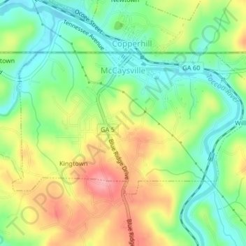
Name: McCaysville topographic map, elevation, terrain.
Location: McCaysville, Fannin County, Georgia, United States (34.97250 -84.38621 34.98815 -84.35309)
Average elevation: 484 m
Minimum elevation: 437 m
Maximum elevation: 548 m
Make a donation
Gear up for your next adventure:
As an Amazon Associate, this site earns from qualifying purchases at no extra cost to you.