Geolocate

Conyers topographic map

Click on the map to display elevation.

About this map

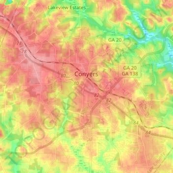
Name: Conyers topographic map, elevation, terrain.

Location: Conyers, Rockdale County, Georgia, United States (33.62497 -84.04573 33.69510 -83.92308)

Average elevation: 251 m

Minimum elevation: 193 m

Maximum elevation: 292 m

Gear up for your next adventure:

📷Outdoor Action Camera - Capture high-elevation views and rugged adventures
🧥Thermal Fleece Jacket - Versatile insulation for changing mountain temperatures
🎒Backpack Rain Cover - External shield to keep your entire pack dry
🦶Anti-Blister Balm - Prevents friction and hotspots during long ascents
🧼Travel Hand Sanitizer - Keep hands clean when water is scarce

As an Amazon Associate, this site earns from qualifying purchases at no extra cost to you.