Geolocate

Shellnut topographic map

Click on the map to display elevation.

About this map

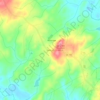
Name: Shellnut topographic map, elevation, terrain.

Location: Shellnut, Heard County, Georgia, 30217, United States (33.28151 -85.15467 33.32151 -85.11467)

Average elevation: 235 m

Minimum elevation: 195 m

Maximum elevation: 298 m

Gear up for your next adventure:

🥾Mountain Trail Shoes - High-traction shoes for mountain trails
💧Collapsible Water Bottle - Space-saving water bottle for outdoor activities
🚲Bike Repair Kit - Essential tools for on-trail mechanical issues
🏕️Camping Hammock - Integrated protection for sleeping between trees
🧢Sun Hat - Wide-brim hat for sun protection

As an Amazon Associate, this site earns from qualifying purchases at no extra cost to you.