Dodge County topographic map
Interactive map
Click on the map to display elevation.
About this map
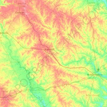
Name: Dodge County topographic map, elevation, terrain.
Location: Dodge County, Georgia, United States (31.90071 -83.37412 32.45243 -82.85804)
Average elevation: 84 m
Minimum elevation: 40 m
Maximum elevation: 141 m
The Heart of Georgia Regional Airport is located three miles east of Eastman off of State Route 46. Elevation 304'. Runway 02/20 is 6,506'x100'and has a precision instrument landing system. The airport is owned by the Heart of Georgia Regional Airport Authority and is home to the Middle Georgia State College Georgia Aviation campus. Middle Georgia State College operates the Federal Aviation Administration's #1 ranked student control tower in the United States. Other businesses at the airport include aircraft manufacturing, aircraft metal finishing, and general metal fabrication. The airport's fixed-base operator is located in the terminal building midfield. The terminal building is named after W. S. Stuckey Sr., founder of Stuckey's Candy Company (now Standard Candy) an aviation pioneer who is from Eastman.
Other topographic maps
Click on a map to view its topography, its elevation and its terrain.
Chatham County
United States > Georgia > Chatham County
Chatham County, Georgia, United States
Average elevation: 3 m
Bonaire
United States > Georgia > Houston County
Bonaire, Houston County, Georgia, 31005, United States
Average elevation: 100 m
Helen
United States > Georgia > White County
Helen, White County, Georgia, 30545, United States
Average elevation: 488 m
Booth Lake
United States > Georgia > Wilkes County > Washington > Ravenwood Park
Booth Lake, Ravenwood Park, Washington, Wilkes County, Georgia, United States
Average elevation: 175 m
Fort Pulaski
United States > Georgia > Chatham County
Fort Pulaski, Fort Perimeter Trail, Chatham County, Georgia, 31328, United States
Average elevation: 1 m
Griffin Lake
United States > Georgia > Brooks County
Griffin Lake, Brooks County, Georgia, United States
Average elevation: 60 m
Rowland Lake
United States > Georgia > Jones County
Rowland Lake, Jones County, Georgia, United States
Average elevation: 175 m
Ponder Park
United States > Georgia > Tift County > Omega
Ponder Park, Omega, Tift County, Georgia, United States
Average elevation: 96 m
Hiawassee
United States > Georgia > Towns County
Hiawassee, Towns County, Georgia, United States
Average elevation: 620 m
Powder Springs
United States > Georgia > Cobb County
Powder Springs, Cobb County, Georgia, United States
Average elevation: 291 m
Brasstown Bald
United States > Georgia > Towns County
Brasstown Bald, Towns County, Georgia, United States
Average elevation: 1,161 m
Adel
United States > Georgia > Cook County
Adel, Cook County, Georgia, 31620, United States
Average elevation: 72 m
Cherokee Hills
United States > Georgia > Coffee County
Cherokee Hills, Coffee County, Georgia, United States
Average elevation: 70 m
Lake City
United States > Georgia > Clayton County
Lake City, Clayton County, Georgia, United States
Average elevation: 287 m
Whitfield County
Whitfield County, Georgia, United States
Average elevation: 258 m
Forbes Lake
United States > Georgia > Macon County
Forbes Lake, Macon County, Georgia, United States
Average elevation: 126 m
Leesburg
United States > Georgia > Lee County
Leesburg, Lee County, Georgia, United States
Average elevation: 76 m
Snodgrass Hill
United States > Georgia > Walker County > Fort Oglethorpe
Snodgrass Hill, Fort Oglethorpe, Walker County, Georgia, 30741, United States
Average elevation: 250 m
Moon River
United States > Georgia > Chatham County > Burnside View
Moon River, Burnside View, Chatham County, Georgia, 31411, United States
Average elevation: 2 m
Rossville
United States > Georgia > Walker County
Rossville, Walker County, Georgia, United States
Average elevation: 251 m
Lake Seminole
United States > Georgia > Seminole County > Chattahoochee
Lake Seminole, Chattahoochee, Seminole County, Georgia, United States
Average elevation: 32 m
Baxley
United States > Georgia > Appling County
Baxley, Appling County, Georgia, 31515, United States
Average elevation: 61 m
Bainbridge
United States > Georgia > Decatur County
Bainbridge, Decatur County, Georgia, United States
Average elevation: 37 m
Shenandoah Woods
United States > Georgia > Columbia County
Shenandoah Woods, Columbia County, Georgia, 30907, United States
Average elevation: 97 m
Hiram
United States > Georgia > Paulding County
Hiram, Paulding County, Georgia, United States
Average elevation: 306 m
Roswell
United States > Georgia > Fulton County
Roswell, Fulton County, Georgia, United States
Average elevation: 316 m
Lawrenceville
United States > Georgia > Gwinnett County
Lawrenceville, Gwinnett County, Georgia, United States
Average elevation: 312 m
High Hill Lake
United States > Georgia > Glynn County
High Hill Lake, Glynn County, Georgia, 31525, United States
Average elevation: 7 m
Newnan
United States > Georgia > Coweta County
Newnan, Coweta County, Georgia, 30263, United States
Average elevation: 272 m
Crowe Lake
United States > Georgia > Gwinnett County
Crowe Lake, Gwinnett County, Georgia, United States
Average elevation: 349 m
Tybee Island
United States > Georgia > Chatham County
Tybee Island, Chatham County, Georgia, 31328, United States
Average elevation: 1 m
Johns Creek
United States > Georgia > Fulton County > Johns Creek
Johns Creek, Fulton County, Georgia, 30097, United States
Average elevation: 305 m
Atlanta
United States > Georgia > Fulton County
Atlanta, Fulton County, Georgia, 30303, United States
Average elevation: 285 m
Peachtree City
United States > Georgia > Fayette County
Peachtree City, Fayette County, Georgia, 30269, United States
Average elevation: 263 m
Milton
United States > Georgia > Fulton County
Milton, Fulton County, Georgia, 30004, United States
Average elevation: 330 m
Colquitt County
Colquitt County, Georgia, United States
Average elevation: 85 m
Bonair
United States > Georgia > Richmond County > Augusta
Bonair, Augusta, Richmond County, Georgia, 30990, United States
Average elevation: 84 m
Douglasville
United States > Georgia > Douglas County
Douglasville, Douglas County, Georgia, United States
Average elevation: 310 m