Geolocate

Winder topographic map

Click on the map to display elevation.

About this map

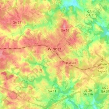
Name: Winder topographic map, elevation, terrain.

Location: Winder, Barrow County, Georgia, 30680, United States (33.93640 -83.76620 34.03697 -83.68046)

Average elevation: 274 m

Minimum elevation: 221 m

Maximum elevation: 322 m

Gear up for your next adventure:

📷Outdoor Action Camera - Capture high-elevation views and rugged adventures
🛌Down Sleeping Bag - Superior warmth-to-weight ratio for cold nights
🔦LED Headtorch - Bright and durable light for night activities
🚑Survival Whistle - Signal for help across long distances in mountains
🛁Quick-Dry Microfiber Towel - Space-saving towel that dries rapidly on the move

As an Amazon Associate, this site earns from qualifying purchases at no extra cost to you.