Geolocate

Waleska topographic map

Click on the map to display elevation.

About this map

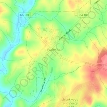
Name: Waleska topographic map, elevation, terrain.

Location: Waleska, Cherokee County, Georgia, United States (34.30116 -84.56302 34.32971 -84.53611)

Average elevation: 335 m

Minimum elevation: 296 m

Maximum elevation: 378 m

Gear up for your next adventure:

🦟Insect Repellent - Keep mosquitoes and black flies away in wooded areas
🔦LED Headtorch - Bright and durable light for night activities
🥾Hiking Leggings - Comfortable leggings for outdoor activities
🧰Emergency Multi-Tool - Compact multi-tool for outdoor survival
💡Solar Camping Lamp - Eco-friendly lighting for campsites

As an Amazon Associate, this site earns from qualifying purchases at no extra cost to you.