
Madison County topographic map
Click on the map to display elevation.
Madison County
A significant portion of western Madison County is within Shenandoah National Park, including Hawksbill Mountain, the highest point in both the park and in Madison County, Old Rag Mountain, one of the park's most popular tourist destinations, and Rapidan Camp, the presidential retreat built by Herbert Hoover. Hoover's Camp was built between 1929 and 1932. The camp consisted of 13 buildings with the main one being "The Brown House". In 2017, only three of these houses are still standing (The Brown House, The Prime Minister Cabin, and The Creel). The camp was built where two streams merge to form the Rapidan River because fishing was Hoover's favorite pastime. Hoover even made sure that the camp was built at an elevation where mosquitos would not be a nuisance while fishing. The camp was donated to the Commonwealth of Virginia in 1932 so other presidents could use it and in December 1935 it officially became a part of Shenandoah National Park.
About this map
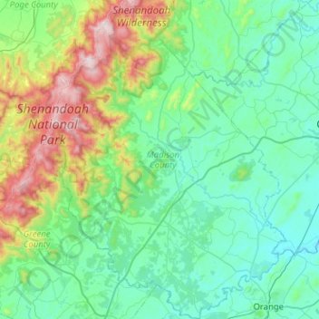
Name: Madison County topographic map, elevation, terrain.
Location: Madison County, Virginia, United States (38.23007 -78.45280 38.62731 -78.08269)
Average elevation: 305 m
Minimum elevation: 82 m
Maximum elevation: 1,216 m
Other topographic maps
Click on a map to view its topography, its elevation and its terrain.
McAfee Knob
United States > Virginia > Roanoke County
McAfee Knob is a geological feature with an elevation of 3,197 feet (974 m) above sea level, located on Catawba Mountain in Catawba, Virginia, roughly 15 miles northwest of Downtown Roanoke. It is named for a Scottish-Irish 18th-century settler. Considered to be among the most iconic points along the…
Average elevation: 657 m
Cumberland Gap
United States > Virginia > Lee County
The Cumberland Gap is a pass in the eastern United States through the long ridge of the Cumberland Mountains, within the Appalachian Mountains and near the tripoint of Kentucky, Virginia, and Tennessee. At an elevation of 1,631 feet (497 m) above sea level, it is famous in American colonial history for its…
Average elevation: 512 m
Lucketts Community Center
United States > Virginia > Loudoun County > Lucketts
Average elevation: 101 m
North Fairlington
United States > Virginia > Arlington County > Arlington > North Fairlington
Average elevation: 54 m