Rif Dimashq Governorate topographic map
Click on the map to display elevation.
About this map
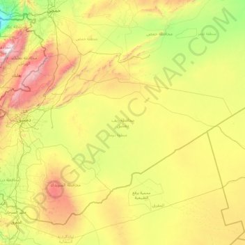
Name: Rif Dimashq Governorate topographic map, elevation, terrain.
Location: Rif Dimashq Governorate, Syria (32.69263 35.81246 34.24892 39.13386)
Average elevation: 742 m
Minimum elevation: -291 m
Maximum elevation: 3,043 m
Other topographic maps
Click on a map to view its topography, its elevation and its terrain.


17 April Park
Syria > Damascus Governorate > Damascus Subdistrict > Kafr Sousa Municipality
Average elevation: 700 m



Harasta
Syria > Rif Dimashq Governorate
Harasta (Arabic: حرستا, romanized: Ḥarastā, Syriac: ܚܪܣܬܐ, romanized: Ḥarastā), also known as Harasta al-Basal or Hirista, is a town and northeastern suburb of Damascus, Rif Dimashq, Syria. Harasta has an altitude of 702 meters. It has a population of 34,184 as of 2007, making it the 43rd…
Average elevation: 880 m


ساحة الميسات
Syria > Damascus Governorate > Damascus Subdistrict > As-Salihiya Municipality
Average elevation: 759 m


حديقة 17 نيسان
Syria > Damascus Governorate > Damascus Subdistrict > Kafr Sousa Municipality
Average elevation: 700 m


Has
Hass (Arabic: حَاسٌّ, romanized: Ḥāss) is a town in northwestern Syria, administratively part of the Ma'arrat al-Numan District of the Idlib Governorate. The town has an altitude of 630 meters above sea level. According to the Syria Central Bureau of Statistics, Hass had a population of 9,595 in the…
Average elevation: 591 m


Zawiya Mountain
Syria > Idleb Governorate > Ar Ruwayhah
The average elevation of Mount Zāwiya is 750 m. The highest point is Mount Ayyūb (939 m). The western side of the mountain is steep, but the eastern side slopes gradually. Many springs and streams arise on the western side and drain into the Rouge and Ghāb plains.
Average elevation: 540 m


Izra
Izraa or Izra (Arabic: إِزْرَع, romanized: Izraʿ) is a city in the Daraa Governorate of Syria, to the north of the city of Daraa. It is the administrative centre of the Izraa District, and sits at an altitude of 599 metres. According to the Syria Central Bureau of Statistics (CBS), Izraa had a…
Average elevation: 583 m


At-Tall
Syria > Rif Dimashq Governorate
Al-Tall (Arabic: التل, romanized: at-Tall, also spelled al-Tell) is a city in southern Syria, administratively part of the Rif Dimashq Governorate and capital of the al-Tall District. Situated in the middle of the Anti-Lebanon Mountains, having an elevation of roughly 1,000 meters above sea level. Nearby…
Average elevation: 1,037 m
Jisr ash-Shugur
Jisr ash-Shughūr (Arabic: جِسْرُ ٱلشُّغُورِ, romanized: jisr aš-šuġūr, pronounced [dʒɪsr aʃ.ʃuˈɣuːr], also rendered as Jisser ash-Shughour and other spellings), known in antiquity as Seleucobelus (Greek: Σελευκόβηλος, romanized: Seleukóbēlos), is a city in the Idlib…
Average elevation: 272 m


Jisr ash-Shugur
Jisr ash-Shughūr (Arabic: جِسْرُ ٱلشُّغُورِ, romanized: jisr aš-šuġūr, pronounced [dʒɪsr aʃ.ʃuˈɣuːr], also rendered as Jisser ash-Shughour and other spellings), known in antiquity as Seleucobelus (Greek: Σελευκόβηλος, romanized: Seleukóbēlos), is a city in the Idlib…
Average elevation: 272 m




Idlib
Idlib (Arabic: إِدْلِب, romanized: ʾIdlib, pronounced [ʔid.lib]; also spelt Idleb or Edlib) is a city in northwestern Syria, and is the capital of the Idlib Governorate. It has an elevation of nearly 500 meters (1,600 ft) above sea level, and is 59 kilometers (37 mi) southwest of Aleppo. The city was…
Average elevation: 394 m


Al-Bab
Al-Bab (Arabic: الْبَاب / ALA-LC: al-Bāb, Kurdish: Derî) is a Syrian city, administratively belonging to the Aleppo Governorate. Al-Bab is located 40 kilometres (25 mi) northeast of Aleppo, 30 kilometres (19 mi) south of the Turkish border, and has an area of 30 square kilometres (12 square miles).…
Average elevation: 471 m




Khan Shaykhoun
Khan Shaykhun is located at an altitude of 350 meters on the main highway between Aleppo and Damascus. The local economy is primarily agricultural, focusing on the growing of cotton and cereals. The town was formerly known for producing embroidery. Nearby localities include Hbit to the west, Kafr Zita to…
Average elevation: 385 m