Geolocate

Al-Malikiya topographic map

Click on the map to display elevation.

About this map
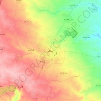
Name: Al-Malikiya topographic map, elevation, terrain.

Location: Al-Malikiya, Al-Malikiya Subdistrict, Al-Malikiya District, Al-Hasaka Governorate, Syria (37.13494 42.10134 37.21494 42.18134)

Average elevation: 487 m

Minimum elevation: 407 m

Maximum elevation: 548 m

Other topographic maps

Click on a map to view its topography, its elevation and its terrain.
Ras al-Ayn

Syria > Al-Hasaka Governorate

Average elevation: 357 m

Gear up for your next adventure:

🏃Hydration Running Vest - Carry water and maps close to your body for speed
🔭Compact Monocular - One-handed bird watching and trail spotting
🧦Thermal Socks - Warm socks for winter hiking or camping
🧳Compression Sacks - Maximize space in your backpack by shrinking gear
👟Leg Gaiters - Keep debris, mud, and snow out of your boots

As an Amazon Associate, this site earns from qualifying purchases at no extra cost to you.