Geolocate

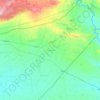
Tartab topographic map

Click on the map to display elevation.

About this map

Name: Tartab topographic map, elevation, terrain.

Location: Tartab, Al-Qamishli Subdistrict, Al-Qamishli District, Al-Hasaka Governorate, Syria (36.99109 41.21256 37.03109 41.25256)

Average elevation: 427 m

Minimum elevation: 413 m

Maximum elevation: 451 m

Other topographic maps

Click on a map to view its topography, its elevation and its terrain.
Ras al-Ayn

Syria > Al-Hasaka Governorate

Average elevation: 357 m

Gear up for your next adventure:

🥾Approach Shoes - Shoes designed for climbing approaches and rugged trails
🧦Thermal Socks - Warm socks for winter hiking or camping
🧴Outdoor Sunscreen - High SPF protection for high-altitude UV exposure
🧢Hiking Hat - Sun-protective and breathable hats for long treks
🧢Beanie Hat - Keep your head warm in cold weather

As an Amazon Associate, this site earns from qualifying purchases at no extra cost to you.