Geolocate

Ad-Dimas topographic map

Click on the map to display elevation.

About this map
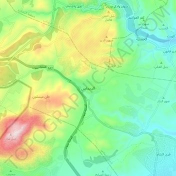
Name: Ad-Dimas topographic map, elevation, terrain.

Location: Ad-Dimas, Ad-Dimas Subdistrict, Qudsaiya District, Rif Dimashq Governorate, Syria (33.54777 36.05211 33.62777 36.13211)

Average elevation: 1,132 m

Minimum elevation: 889 m

Maximum elevation: 1,631 m

Other topographic maps

Click on a map to view its topography, its elevation and its terrain.

Qudsaiya District

Syria > Rif Dimashq Governorate

Average elevation: 1,322 m

Qatana District

Syria > Rif Dimashq Governorate

Average elevation: 1,122 m

Al Nabek dam

Syria > Rif Dimashq Governorate

Average elevation: 1,247 m

Qatana District

Syria > Rif Dimashq Governorate

Average elevation: 1,122 m

Duma District

Syria > Rif Dimashq Governorate

Average elevation: 801 m

Zarzar Lake

Syria > Rif Dimashq Governorate

Average elevation: 1,201 m

Gear up for your next adventure:

🔥Camping Stove - Portable stoves to cook outdoors with ease
💧Collapsible Water Bottle - Space-saving water bottle for outdoor activities
🧰Survival Kit - Essential gear for emergencies in the wilderness
🧢Beanie Hat - Keep your head warm in cold weather
🦌Outdoor Trail Camera - Monitor wildlife activity near your favorite spots

As an Amazon Associate, this site earns from qualifying purchases at no extra cost to you.