Geolocate

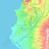
Bekrama topographic map

Click on the map to display elevation.

About this map

Name: Bekrama topographic map, elevation, terrain.

Location: Bekrama, Al-Qardaha Subdistrict, Al-Qardaha District, Latakia Governorate, Syria (35.40413 36.09588 35.44413 36.13588)

Average elevation: 576 m

Minimum elevation: 289 m

Maximum elevation: 856 m

Other topographic maps

Click on a map to view its topography, its elevation and its terrain.

سد برادون

Syria > Latakia Governorate

Average elevation: 227 m

Lattakia District

Syria > Latakia Governorate

Average elevation: 284 m

Lattakia District

Syria > Latakia Governorate

Average elevation: 284 m

Gear up for your next adventure:

🚲Bike Repair Kit - Essential tools for on-trail mechanical issues
🔋Lithium AA Batteries - Long-lasting power that performs in extreme cold
🔋Solar Power Bank - Keep your GPS and devices charged during long outdoor trips
🧥Thermal Layer - Insulating layer for cold outdoor conditions
🛌Insulated Sleeping Pad - Critical thermal barrier between you and the cold ground

As an Amazon Associate, this site earns from qualifying purchases at no extra cost to you.