Geolocate

Far-Western Development Region topographic map

Click on the map to display elevation.

Far-Western Development Region

The Far-Western Region covered 19,539 square kilometers. It had nine districts with the regional headquarters at Dipayal, Doti district. The Far-Western Region was remote and developmentally challenged. Some 44% of people in the Far West Hills and 49% in the Himalayan districts lived below the poverty line. The region had limited basic services. The difficult topography complicated development. The region had complex socio-economic structures along with widespread gender- and caste-based discrimination. Traditional systems associated with religion, culture and customs had limited overall development.

About this map

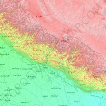
Name: Far-Western Development Region topographic map, elevation, terrain.

Location: Far-Western Development Region, Sudurpashchim Pradesh, Nepal (26.97105 78.00673 32.17105 83.20673)

Average elevation: 2,505 m

Minimum elevation: 76 m

Maximum elevation: 7,878 m

Other topographic maps

Click on a map to view its topography, its elevation and its terrain.

Itahari

Nepal > Sunsari

Average elevation: 116 m

Kuwari Khola

Nepal > Sudurpashchim Province > Bajura > Yuna

Average elevation: 2,335 m

Neshyang

Nepal > Gandaki Province > Manang

Average elevation: 4,968 m

Annapurna

Nepal > Gandaki Province > Kaski

Average elevation: 2,974 m

Baitadi

Nepal > Sudurpashchim Province

Average elevation: 1,529 m

Butwal

Nepal > Butwal

Average elevation: 357 m

Baikunthapur

Nepal > Lumbini Province > Nawalparasi W

Average elevation: 113 m

Butwal

Nepal > Lumbini Province > Rupandehi

Average elevation: 280 m

Mustang

Nepal > Gandaki Province

The district is a part of Gandaki Province in northern Nepal, straddles the Himalayas and extends northward onto the Tibetan Plateau. The district is one of the remotest areas in Nepal and is second in terms of the sparsity of population. The elevation ranges from 1,372 to 8,167 meters (Mount Dhaulagiri, the…

Average elevation: 4,938 m

Sunapati

Nepal > Bagmati Province > Ramechhap

Average elevation: 1,419 m

Taplejung

Nepal > Koshi Province

Geographically Taplejung is a mountainous district where the world's third highest peak Kanchenjunga (8586 m) is located. It is situated at elevation ranging from 670 metres (2,200 ft) to 8,586 metres (28,169 ft) from sea level.

Average elevation: 3,894 m

Bhotechaur

Nepal > Sindhupalchowk

Average elevation: 1,606 m

Ghatte Khola

Nepal > Bhaktapur > Anantalingeshwar

Average elevation: 1,329 m

Hariyon

Nepal > Sarlahi > Hariaun Krisnachok

Average elevation: 156 m

Bardibas

Nepal > Madhesh Province > Mahottari

Average elevation: 287 m

Nijgadh

Nepal > Bara

Average elevation: 218 m

Mahalaxmi

Nepal > Dhankuta

Average elevation: 1,342 m

Janakpur

Nepal > Dhanusha

Average elevation: 76 m

Jayanagar

Nepal > Kapilvastu > Buddhabatika

Average elevation: 113 m

Sandhikharka

Nepal > Arghakhanchi

Average elevation: 1,245 m

Buddhabatika

Nepal > Kapilvastu > Buddhabatika

Average elevation: 283 m

Byas

Nepal > Tanahun

Average elevation: 664 m

Dhading

Nepal > Dhading

Average elevation: 1,704 m

Salang

Nepal > Dhading > Salang

Average elevation: 717 m

Sarlahi

Nepal > Sarlahi

Average elevation: 150 m

Tansen

Nepal > Palpa

Average elevation: 986 m

Narayanpur

Nepal > Dang > Tripur

Average elevation: 631 m

Tripur

Nepal > Dang > Tripur

Average elevation: 786 m

Tamghas

Nepal > Gulmi > Tamghas

Average elevation: 1,450 m

Pattharkot

Nepal > Sarlahi > Lalbandi

Average elevation: 234 m

Bangesal

Nepal > Pyuthan > Bangesal

Average elevation: 612 m

Thada

Nepal > Arghakhanchi > Thada

Average elevation: 953 m

Bandipur

Nepal > Tanahun

Average elevation: 698 m

Rugin

Nepal > Bajura > Rugin

Average elevation: 2,074 m

Khidim

Nepal > Arghakhanchi > Khidim

Average elevation: 994 m

Tilottama

Nepal > Rupandehi > Tilottama

Average elevation: 125 m

Lapilang

Nepal > Dolakha > Lapilang

Average elevation: 2,055 m

Dhorpatan

Nepal > Baglung

Average elevation: 2,454 m

Birendranagar

Nepal > Surkhet

Average elevation: 926 m

Raskot

Nepal > Kalikot

Average elevation: 2,285 m

Siddhalek

Nepal > Dhading

Average elevation: 765 m

Thulapokhara

Nepal > Arghakhanchi

Average elevation: 1,069 m

Nepa

Nepal > Dailekh

Average elevation: 1,126 m

Gear up for your next adventure:

🚲Heavy Duty Bike Lock - Secure your bike at the trailhead or during stops
🧴Waterproofing Spray - Restore the DWR coating on jackets and tents
🥫Freeze-Dried Meals - Lightweight, high-calorie nutrition for multi-day treks
🥾Hiking Gaiters - Protect legs and shoes from mud, snow, and debris
🧣Merino Neck Gaiter - Protects against wind, sun, and cold at high altitudes

As an Amazon Associate, this site earns from qualifying purchases at no extra cost to you.