
Tansen topographic map
Click on the map to display elevation.
About this map
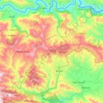
Name: Tansen topographic map, elevation, terrain.
Location: Tansen, Palpa, Lumbini Province, 22400, Nepal (27.79369 83.41909 27.94071 83.58369)
Average elevation: 986 m
Minimum elevation: 399 m
Maximum elevation: 1,702 m
Other topographic maps
Click on a map to view its topography, its elevation and its terrain.