
Mustang topographic map
Click on the map to display elevation.
Mustang
The district is a part of Gandaki Province in northern Nepal, straddles the Himalayas and extends northward onto the Tibetan Plateau. The district is one of the remotest areas in Nepal and is second in terms of the sparsity of population. The elevation ranges from 1,372 to 8,167 meters (Mount Dhaulagiri, the 7th highest mountain in the world), with several peaks above 7,000 meters.
About this map
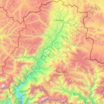
Name: Mustang topographic map, elevation, terrain.
Location: Mustang, Gandaki Province, 33100, Nepal (28.56450 83.47900 29.33125 84.25171)
Average elevation: 4,938 m
Minimum elevation: 2,335 m
Maximum elevation: 8,142 m
Other topographic maps
Click on a map to view its topography, its elevation and its terrain.
Manaslu
Nepal > Gandaki Province > Gorkha
The Manaslu region offers a variety of trekking options. The popular Manaslu trekking route of 177 kilometres (110 mi) skirts the Manaslu massif over the pass down to Annapurna. The Nepalese Government only permitted trekking on this circuit in 1991. The trekking trail follows an ancient salt-trading route…
Average elevation: 7,069 m