Geolocate

Dhading topographic map

Click on the map to display elevation.

About this map

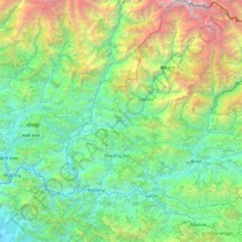
Name: Dhading topographic map, elevation, terrain.

Location: Dhading, Bagmati Pradesh, Nepal (27.66845 84.61798 28.34636 85.27096)

Average elevation: 1,704 m

Minimum elevation: 221 m

Maximum elevation: 7,039 m

Gear up for your next adventure:

Camping Essentials - All-in-one gear for a comfortable camping trip
🥽Outdoor Goggles - Protective eyewear for outdoor activities
❄️Traction Ice Cleats - Slip-on spikes for icy trails and winter hiking
💧Filtered Water Bottle - Safe drinking water on the go
🥾Hiking Leggings - Comfortable leggings for outdoor activities

As an Amazon Associate, this site earns from qualifying purchases at no extra cost to you.