
Uganda topographic map
Interactive map
Click on the map to display elevation.
About this map
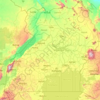
Name: Uganda topographic map, elevation, terrain.
Location: Uganda (-1.48232 29.57343 4.23408 35.00031)
Average elevation: 1,157 m
Minimum elevation: 500 m
Maximum elevation: 4,464 m
Other topographic maps
Click on a map to view its topography, its elevation and its terrain.
Vancouver
Canada > British Columbia > Metro Vancouver Regional District
Vancouver, Metro Vancouver Regional District, British Columbia, Canada
Average elevation: 34 m
Winnipeg
Canada > Manitoba > Division No. 11
Winnipeg, Division No. 11, Manitoba, Canada
Average elevation: 236 m
Edmonton
Canada > Alberta > Division No. 11
Edmonton, Division No. 11, Alberta, Canada
Average elevation: 690 m
Vancouver Island
Vancouver Island, British Columbia, Canada
Average elevation: 411 m
Canada
Canada
Average elevation: 254 m
Montreal
Canada > Quebec > Urban agglomeration of Montreal
Montreal, Urban agglomeration of Montreal, Montreal (administrative region), Quebec, Canada
Average elevation: 29 m
Oakville
Canada > Ontario > Halton Region
Oakville, Halton Region, Golden Horseshoe, Ontario, Canada
Average elevation: 104 m
Kamloops
Canada > British Columbia > Thompson-Nicola Regional District
Kamloops, Thompson-Nicola Regional District, British Columbia, Canada
Average elevation: 833 m
Colorado Springs
United States > Colorado > El Paso County
Colorado Springs, El Paso County, Colorado, United States
Average elevation: 2,252 m
Mission
Canada > British Columbia > Fraser Valley Regional District
Mission, Fraser Valley Regional District, British Columbia, Canada
Average elevation: 345 m
Victoria
Canada > British Columbia > Capital Regional District
Victoria, Capital Regional District, British Columbia, Canada
Average elevation: 17 m
USA
United States > Texas > Tarrant County > Arlington
USA, Arlington, Tarrant County, Texas, 76011, United States
Average elevation: 170 m
Lubbock
United States > Texas > Lubbock County
Lubbock, Lubbock County, Texas, United States
Average elevation: 983 m
Worcester County
Worcester County, Massachusetts, United States
Average elevation: 192 m
Yellowstone National Park
Yellowstone National Park, Wyoming, United States
Average elevation: 2,450 m
Manitoulin Island
Canada > Ontario > Manitoulin District
Manitoulin Island, Manitoulin District, Northeastern Ontario, Ontario, Canada
Average elevation: 194 m
Baton Rouge
United States > Louisiana > East Baton Rouge Parish
Baton Rouge, East Baton Rouge Parish, Louisiana, United States
Average elevation: 13 m
Metro Vancouver Regional District
Metro Vancouver Regional District, British Columbia, Canada
Average elevation: 343 m
Kitchener
Canada > Ontario > Region of Waterloo
Kitchener, Region of Waterloo, Southwestern Ontario, Ontario, Canada
Average elevation: 336 m
Quebec
Canada > Quebec > Urban agglomeration of Québec
Quebec, Urban agglomeration of Québec, Capitale-Nationale, Quebec, Canada
Average elevation: 117 m
Burnaby
Canada > British Columbia > Metro Vancouver Regional District
Burnaby, Metro Vancouver Regional District, British Columbia, Canada
Average elevation: 59 m
Surrey
Canada > British Columbia > Metro Vancouver Regional District
Surrey, Metro Vancouver Regional District, British Columbia, Canada
Average elevation: 28 m
Saskatoon
Canada > Saskatchewan > Division No. 11
Saskatoon, Division No. 11, Saskatchewan, Canada
Average elevation: 504 m
Orange County
Orange County, California, United States
Average elevation: 112 m
Coquitlam
Canada > British Columbia > Metro Vancouver Regional District
Coquitlam, Metro Vancouver Regional District, British Columbia, Canada
Average elevation: 190 m
Halifax
Canada > Nova Scotia > Halifax County
Halifax, Halifax Regional Municipality, Halifax County, Nova Scotia, Canada
Average elevation: 46 m
Gaylord
United States > Michigan > Otsego County > Gaylord
Gaylord, Otsego County, Michigan, United States
Average elevation: 401 m
Victoria
Canada > British Columbia > Capital Regional District > Victoria
Victoria, Capital Regional District, British Columbia, V8W 1P6, Canada
Average elevation: 47 m
Pittsburgh
United States of America > Pennsylvania > Pittsburgh
Pittsburgh, Allegheny County, Pennsylvania, 15262, United States of America
Average elevation: 315 m
Saint Mary's County
Saint Mary's County, Maryland, United States
Average elevation: 13 m