
Make a donation
Gear up for your next adventure:
As an Amazon Associate, this site earns from qualifying purchases at no extra cost to you.
Yellowstone National Park topographic map
Click on the map to display elevation.
Make a donation
Gear up for your next adventure:
As an Amazon Associate, this site earns from qualifying purchases at no extra cost to you.
Yellowstone National Park
Yellowstone National Park spans an area of 3,468.4 sq mi (8,983 km2), comprising lakes, canyons, rivers, and mountain ranges. Yellowstone Lake is one of the largest high-elevation lakes in North America and is centered over the Yellowstone Caldera, the largest supervolcano on the continent. The caldera is considered a dormant volcano. It has erupted with tremendous force several times in the last two million years. Well over half of the world's geysers and hydrothermal features are in Yellowstone, fueled by this ongoing volcanism. Lava flows and rocks from volcanic eruptions cover most of the land area of Yellowstone. The park is the centerpiece of the Greater Yellowstone Ecosystem, the largest remaining nearly-intact ecosystem in the Earth's northern temperate zone. In 1978, Yellowstone was named a UNESCO World Heritage Site.
Make a donation
Gear up for your next adventure:
As an Amazon Associate, this site earns from qualifying purchases at no extra cost to you.
About this map
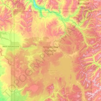
Name: Yellowstone National Park topographic map, elevation, terrain.
Location: Yellowstone National Park, Wyoming, United States (44.13158 -111.15599 45.10896 -109.82549)
Average elevation: 2,450 m
Minimum elevation: 1,560 m
Maximum elevation: 3,549 m
Make a donation
Gear up for your next adventure:
As an Amazon Associate, this site earns from qualifying purchases at no extra cost to you.
Other topographic maps
Click on a map to view its topography, its elevation and its terrain.
Rocky Mountains
United States > Wyoming > Teton County
Agriculture and forestry are major industries. Agriculture includes dryland and irrigated farming and livestock grazing. Livestock are frequently moved between high-elevation summer pastures and low-elevation winter pastures, a practice known as transhumance.
Average elevation: 2,292 m
Mount Washburn
United States > Wyoming > Park County
Mount Washburn, elevation 10,219 feet (3,115 m), is a prominent mountain peak in the Washburn Range in Yellowstone National Park, Wyoming. The peak was named in 1870 to honor Henry D. Washburn, leader of the Washburn–Langford–Doane Expedition. The Washburn Range is one of two mountains ranges completely…
Average elevation: 2,798 m
Make a donation
Gear up for your next adventure:
As an Amazon Associate, this site earns from qualifying purchases at no extra cost to you.
Buck Mountain
United States > Wyoming > Teton County
Buck Mountain (elevation: 11,943 feet (3,640 m)) is a mountain located in the Teton Range, Grand Teton National Park, Wyoming, immediately southeast of Grand Teton.
Average elevation: 3,128 m
Rocky Mountains
United States > Wyoming > Teton County
Agriculture and forestry are major industries. Agriculture includes dryland and irrigated farming and livestock grazing. Livestock are frequently moved between high-elevation summer pastures and low-elevation winter pastures, a practice known as transhumance.
Average elevation: 2,292 m
Make a donation
Gear up for your next adventure:
As an Amazon Associate, this site earns from qualifying purchases at no extra cost to you.
Gannett Peak
United States > Wyoming > Fremont County
Gannett Peak is the highest mountain peak in the U.S. state of Wyoming at 13,810 feet (4,210 m). It lies in the Wind River Range within the Bridger Wilderness of the Bridger-Teton National Forest. Straddling the Continental Divide along the boundary between Fremont and Sublette counties, it has the second…
Average elevation: 3,700 m
Make a donation
Gear up for your next adventure:
As an Amazon Associate, this site earns from qualifying purchases at no extra cost to you.
Goshen County Fair Grounds
United States > Wyoming > Goshen County > Torrington
Average elevation: 1,258 m
Make a donation
Gear up for your next adventure:
As an Amazon Associate, this site earns from qualifying purchases at no extra cost to you.
Make a donation
Gear up for your next adventure:
As an Amazon Associate, this site earns from qualifying purchases at no extra cost to you.
Teton Range
United States > Wyoming > Teton County
One reason the Teton Range is famous is because of the dramatic elevation profile visible from the eastern side, which rises sharply from 4,000 to 7,000 feet (1,200–2,100 m) above the valley floor. Unlike most mountain ranges, the east side of the Teton Range lacks significant foothills or lower peaks which…
Average elevation: 2,985 m
Cloud Peak
United States > Wyoming > Big Horn County
Located in the 189,000-acre (765 km2) Cloud Peak Wilderness within Bighorn National Forest, the peak rises to an elevation of 13,171 feet (4,015 m). It can be climbed most easily from the western side, accessed by either the Battle Park or West Tensleep trailheads, which both form 24-mile (39 km) round trips…
Average elevation: 3,598 m
Make a donation
Gear up for your next adventure:
As an Amazon Associate, this site earns from qualifying purchases at no extra cost to you.
Casper Mountain
United States > Wyoming > Natrona County
Casper Mountain, an anticline, is located at the north end of the Laramie Mountains overlooking Casper, Wyoming along the North Platte River. At a top elevation of 8,130 feet (2,478 m), the geological feature rises approximately 3,000 feet (914 m) above Casper.
Average elevation: 2,315 m
Jenny Lake
United States > Wyoming > Teton County
Jenny Lake is a starting point for many day and overnight hiking trips. The 7.1-mile (11.4 km) Jenny Lake Trail loops around the lake and is considered to be relatively easy due to the small altitude gain of 700 feet (210 m). However, the altitude increases rapidly once Cascade Canyon is entered.
Average elevation: 2,109 m
Make a donation
Gear up for your next adventure:
As an Amazon Associate, this site earns from qualifying purchases at no extra cost to you.
Make a donation
Gear up for your next adventure:
As an Amazon Associate, this site earns from qualifying purchases at no extra cost to you.
Medicine Bow Peak
United States > Wyoming > Albany County
Medicine Bow Peak (12,018 ft (3,663 m)) is the highest peak in the Snowy Range, a part of the Medicine Bow Mountains, about 35 miles (56 km) west of Laramie, Wyoming. It lies within Medicine Bow National Forest and is the highest point in southern Wyoming. The summit lies in extreme western Albany County, but…
Average elevation: 3,396 m
Make a donation
Gear up for your next adventure:
As an Amazon Associate, this site earns from qualifying purchases at no extra cost to you.
Togwotee Pass
United States > Wyoming > Teton County
Togwotee Pass (pronounced TOH-guh-tee) is a high mountain pass in the western United States, at an elevation of 9,655 feet (2,943 m) above sea level. On the Continental Divide in the Absaroka Range of northwestern Wyoming in Teton County, it is between Dubois and Moran Junction in the Jackson Hole valley.
Average elevation: 2,965 m
Make a donation
Gear up for your next adventure:
As an Amazon Associate, this site earns from qualifying purchases at no extra cost to you.
Druid Peak
United States > Wyoming > Park County
Druid Peak (elevation 9,577 feet (2,919 m)) is a moderate domed peak on the southern flank of the Absaroka Range in Yellowstone National Park. The peak lies just north of the Lamar River and Soda Butte Creek confluence at the head of the Lamar Valley. Prior to 1885, this summit was named Soda Hill by members…
Average elevation: 2,597 m
Make a donation
Gear up for your next adventure:
As an Amazon Associate, this site earns from qualifying purchases at no extra cost to you.
Make a donation
Gear up for your next adventure:
As an Amazon Associate, this site earns from qualifying purchases at no extra cost to you.
Rocky Mountains
United States > Wyoming > Teton County
Agriculture and forestry are major industries. Agriculture includes dryland and irrigated farming and livestock grazing. Livestock are frequently moved between high-elevation summer pastures and low-elevation winter pastures, a practice known as transhumance.
Average elevation: 2,292 m
Make a donation
Gear up for your next adventure:
As an Amazon Associate, this site earns from qualifying purchases at no extra cost to you.
Hayden Valley
United States > Wyoming > Park County
A grassy valley, branching between low ridges, running from the river toward the center of the basin. A small stream rose in this valley, breaking through the ridges to the west in a deep cañon, and falling into the channel of the Yellowstone, which here bears in a northeast course, flowing in view as far as…
Average elevation: 2,373 m
Make a donation
Gear up for your next adventure:
As an Amazon Associate, this site earns from qualifying purchases at no extra cost to you.
Gannett Peak
United States > Wyoming > Fremont County
Gannett Peak is the highest mountain peak in the U.S. state of Wyoming at 13,810 feet (4,210 m). It lies in the Wind River Range within the Bridger Wilderness of the Bridger-Teton National Forest. Straddling the Continental Divide along the boundary between Fremont and Sublette counties, it has the second…
Average elevation: 3,700 m
Make a donation
Gear up for your next adventure:
As an Amazon Associate, this site earns from qualifying purchases at no extra cost to you.
Buck Mountain
United States > Wyoming > Teton County
Buck Mountain (elevation: 11,943 feet (3,640 m)) is a mountain located in the Teton Range, Grand Teton National Park, Wyoming, immediately southeast of Grand Teton.
Average elevation: 3,128 m
Make a donation
Gear up for your next adventure:
As an Amazon Associate, this site earns from qualifying purchases at no extra cost to you.
Make a donation
Gear up for your next adventure:
As an Amazon Associate, this site earns from qualifying purchases at no extra cost to you.
Make a donation
Gear up for your next adventure:
As an Amazon Associate, this site earns from qualifying purchases at no extra cost to you.
Make a donation
Gear up for your next adventure:
As an Amazon Associate, this site earns from qualifying purchases at no extra cost to you.
Make a donation
Gear up for your next adventure:
As an Amazon Associate, this site earns from qualifying purchases at no extra cost to you.
Make a donation
Gear up for your next adventure:
As an Amazon Associate, this site earns from qualifying purchases at no extra cost to you.
Laramie
United States > Wyoming > Albany County
Laramie (/ˈlærəmi/) is a city in and the county seat of Albany County, Wyoming, United States, known for its high elevation at 7,200 feet (2,200 m), railroad history, and is the home of the University of Wyoming. The population was 31,407 at the 2020 census, making it the fourth-most populous city in…
Average elevation: 2,218 m
Make a donation
Gear up for your next adventure:
As an Amazon Associate, this site earns from qualifying purchases at no extra cost to you.
Laramie
United States > Wyoming > Albany County
Laramie (/ˈlærəmi/) is a city in and the county seat of Albany County, Wyoming, United States, known for its high elevation at 7,200 feet (2,200 m), for its railroad history, and as the home of the University of Wyoming. The population was 31,407 at the 2020 census, making it the fourth-most populous city…
Average elevation: 2,218 m
Make a donation
Gear up for your next adventure:
As an Amazon Associate, this site earns from qualifying purchases at no extra cost to you.
Make a donation
Gear up for your next adventure:
As an Amazon Associate, this site earns from qualifying purchases at no extra cost to you.
Make a donation
Gear up for your next adventure:
As an Amazon Associate, this site earns from qualifying purchases at no extra cost to you.