
Worcester County topographic map
Click on the map to display elevation.
About this map
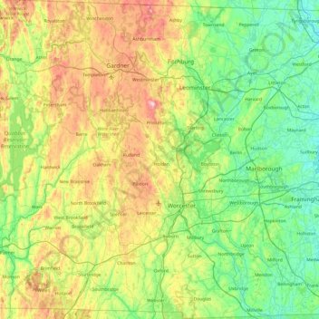
Name: Worcester County topographic map, elevation, terrain.
Location: Worcester County, Massachusetts, United States (42.00805 -72.31588 42.72159 -71.47803)
Average elevation: 192 m
Minimum elevation: 27 m
Maximum elevation: 605 m
Other topographic maps
Click on a map to view its topography, its elevation and its terrain.
Cape Cod Bay
The Cape's lifeline is groundwater. Rain and melting snow swiftly sink into the sandy soils, where it pools to form a massive subterranean groundwater reservoir beneath the majority of the Cape. Groundwater continues to flow into and out of ponds, feeding streams, and flowing towards the coast, finding sea…
Average elevation: 0 m
South Chelmsford
United States > Massachusetts > Middlesex County > Chelmsford
Average elevation: 65 m
Williams Conservation Land
United States > Massachusetts > Essex County > Wenham
Average elevation: 23 m
Rockaway Conservation Area
United States > Massachusetts > Essex County > Peabody
Average elevation: 36 m
South Dennis
United States > Massachusetts > Barnstable County > Dennis > South Dennis
Average elevation: 9 m
Haverhill
United States > Massachusetts > Essex County > Haverhill
According to the United States Census Bureau, the city has a total area of 35.6 square miles (92.3 km2), of which 33.0 square miles (85.4 km2) is land and 2.7 square miles (6.9 km2), or 7.47%, is water. The city ranks 60th in the Commonwealth in terms of land area, and is the largest city or town in Essex…
Average elevation: 45 m
South Sudbury
United States > Massachusetts > Middlesex County > Sudbury > South Sudbury
Average elevation: 53 m
South End
United States > Massachusetts > Hampden County > Springfield > South End
Average elevation: 37 m
CR #10
United States > Massachusetts > Barnstable County > Falmouth > Saconesset Hills
Average elevation: 14 m
Haywardville
United States > Massachusetts > Middlesex County > Stoneham > Haywardville
Average elevation: 46 m
Lake Mirimichi Dam
United States > Massachusetts > Norfolk County > Foxborough
Average elevation: 52 m
North Reading
United States > Massachusetts > Middlesex County > North Reading
Average elevation: 33 m
Doolittle Brook Conservation Area
United States > Massachusetts > Franklin County > Leverett
Average elevation: 192 m
Annisquam
United States > Massachusetts > Essex County > Gloucester > Annisquam
Average elevation: 14 m
South Barre
United States > Massachusetts > Worcester County > Barre > South Barre
Average elevation: 223 m