
Saskatoon topographic map
Click on the map to display elevation.
Saskatoon
Saskatoon lies on a long belt of rich, potassic chernozem in middle-southern Saskatchewan and is found in the aspen parkland biome. The lack of surrounding mountainous topography gives the city a relatively flat grid, though the city does sprawl over a few hills and into a few valleys. The lowest point in the city is the river, while the highest point is disputed between the suburb of Sutherland in the east side and the Silverwood-River Heights areas in the city's north end. Saskatoon, on a cross-section from west to east, has a general decline in elevation above sea level heading towards the river, and on the east bank of the river, the terrain is mostly level until outside the city, where it begins to decrease in elevation again.
About this map
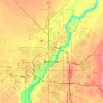
Name: Saskatoon topographic map, elevation, terrain.
Location: Saskatoon, Saskatchewan, Canada (52.06980 -106.82497 52.23114 -106.50370)
Average elevation: 504 m
Minimum elevation: 462 m
Maximum elevation: 535 m
Saskatchewan trails, hiking, mountain biking, running and outdoor activities
Other topographic maps
Click on a map to view its topography, its elevation and its terrain.
Clearwater River
Canada > Saskatchewan > Division No. 18 > Unorganized Division No. 18
From Broach Lake at an elevation of 460 metres (1,510 ft) above sea level, the Clearwater drops about 150 metres (490 ft) to the confluence at Fort McMurray. Its waters eventually reach the Arctic Ocean via the Athabasca and Mackenzie Rivers. Tributaries of the Clearwater River include Descharme River and…
Average elevation: 450 m
McClean Lake
Canada > Saskatchewan > Division No. 18 > Unorganized Division No. 18
Average elevation: 440 m
La Loche
Canada > Saskatchewan > Northern Saskatchewan Administration District > La Loche
Average elevation: 447 m
Pelican Narrows
Canada > Saskatchewan > Northern Saskatchewan Administration District > Pelican Narrows
Average elevation: 321 m