
Mackenzie River topographic map
Click on the map to display elevation.
Mackenzie River
The Mackenzie widens considerably to about 6 to 7 kilometres (3.7 to 4.3 mi) at Norman Wells, a major centre of oil production. There is a narrows at the Mountain River confluence called the Sans Sault Rapids, where the Mackenzie falls about 6 metres (20 ft). Below the Mountain River the Mackenzie flows due north until reaching The Ramparts, a limestone gorge barely 500 metres (1,600 ft) wide and up to 45 metres (148 ft) deep. Below The Ramparts is the village of Fort Good Hope, where the Mackenzie turns northwest again, soon crossing the Arctic Circle. The Mackenzie here flows slightly lower in elevation than the surrounding tundra, as a braided river between low bluffs about 3 to 5 kilometres (1.9 to 3.1 mi) apart. It receives the Arctic Red River from the southwest at Tsiigehtchic, where traffic on the Dempster Highway crosses via ferry/ice bridge.
About this map
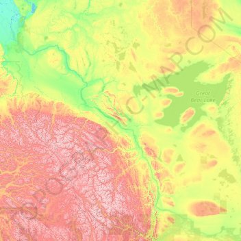
Name: Mackenzie River topographic map, elevation, terrain.
Location: Mackenzie River, Canada (61.02172 -136.56312 69.37357 -116.50000)
Average elevation: 655 m
Minimum elevation: -3 m
Maximum elevation: 4,873 m
Canada trails, hiking, mountain biking, running and outdoor activities
Other topographic maps
Click on a map to view its topography, its elevation and its terrain.
Toronto
Despite its deep ravines, Toronto is not remarkably hilly, but its elevation does increase steadily away from the lake. Elevation differences range from 76.5 metres (251 ft) above sea level at the Lake Ontario shore to 209 m (686 ft) ASL near the York University grounds in the city's north end at the…
Average elevation: 113 m
Banff
Canada > Alberta > Banff > Banff
Banff is a town within Banff National Park in Alberta, Canada. It is located in Alberta's Rockies along the Trans-Canada Highway, approximately 126 km (78 mi) west of Calgary and 58 km (36 mi) east of Lake Louise. At 1,400 to 1,630 m (4,590 to 5,350 ft) above sea level, Banff is the community with the second…
Average elevation: 1,615 m
London
Canada > Ontario > London > London
London has a humid continental climate (Köppen Dfb), though due to its downwind location relative to Lake Huron and elevation changes across the city, it is virtually on the Dfa/Dfb (hot summer) boundary favouring the former climate zone to the southwest of the confluence of the South and North Thames Rivers,…
Average elevation: 268 m
Guelph
This region of Ontario has cold winters and warm, humid summers, falling into the Köppen climate classification Dfb zone, with moderately high rainfall and snowfall. It is generally a couple of degrees cooler than lower elevation regions on the Great Lakes shorelines, especially so in winter, the exception…
Average elevation: 344 m
Burnaby
Canada > British Columbia > Metro Vancouver Regional District > Burnaby
Burnaby occupies 98.60 square kilometres (38.07 sq mi) and is located at the geographic centre of the Metro Vancouver area and home to the Metro Vancouver regional government in Metrotown. Situated between the city of Vancouver on the west and Port Moody, Coquitlam, and New Westminster on the east, Burnaby is…
Average elevation: 144 m
Peterborough
Canada > Ontario > Peterborough
Peterborough's topography is largely defined by land formations created by the receding Wisconsian glaciers 10,000–15,000 years ago. The South End and Downtown portions of the City sit on what was the bottom of the glacial Lake Peterborough—part of a glacial spillway created when glacial meltwaters from…
Average elevation: 235 m
Kokanee Creek
Canada > British Columbia > Regional District of Central Kootenay > Area E (Balfour/Cottonwood Lake)
Average elevation: 2,022 m
Tête-à-la-Baleine
Canada > Quebec > Le Golfe-du-Saint-Laurent > Côte-Nord-du-Golfe-du-Saint-Laurent
Average elevation: 24 m
Chehalis Lake
Canada > British Columbia > Fraser Valley Regional District > Area C (Sasquatch Country)
Average elevation: 735 m
150 Mile House
Canada > British Columbia > Cariboo Regional District > Area F (Horsefly/Likely/150 Mile House)
Average elevation: 789 m
Sioux Narrows
Canada > Ontario > Kenora District > Sioux Narrows-Nestor Falls Township
Average elevation: 329 m
Cochrane
Canada > Alberta > Town of Cochrane > Cochrane
Cochrane is situated at the base of Big Hill in the Bow River Valley. It sits at an elevation of 1,186 m (3,891 ft). The town is intersected by Highway 1A and Highway 22. Cochrane has a reputation for its western culture, which can easily be felt when one wanders the streets (particularly Main Street). The…
Average elevation: 1,205 m
Woodlot 0007
Canada > British Columbia > Metro Vancouver Regional District > Maple Ridge
Average elevation: 322 m
Elbow Lake
Canada > British Columbia > Cariboo Regional District > Area F (Horsefly/Likely/150 Mile House)
Average elevation: 959 m
Laurentian Mountains
One of Quebec's official regions is called Laurentides. The mountain range runs through four other regions; Capitale-Nationale, Outaouais, Lanaudière, and Mauricie. The elevation generally ranges from around 500 m (1,640 ft) to 1,000 m (3,280 ft) with Mont Raoul-Blanchard being its highest peak, at 1,166 m…
Average elevation: 348 m
Carroll Lake
Canada > Ontario > Kenora District > Unorganized Kenora District
Average elevation: 338 m
Chignecto Isthmus
Canada > Nova Scotia > Municipality of the County of Cumberland > Fort Lawrence
Average elevation: 14 m
Grouse Mountain
Canada > British Columbia > Metro Vancouver Regional District
Grouse Mountain is one of the North Shore Mountains of the Pacific Ranges in the District Municipality of North Vancouver, British Columbia, Canada. With a maximum elevation of over 1,200 m (4,100 feet) at its peak, the mountain is the site of an alpine ski area, Grouse Mountain Resort, which overlooks Greater…
Average elevation: 968 m
Glen Robertson
Canada > Ontario > Stormont, Dundas and Glengarry Counties > North Glengarry
Average elevation: 78 m
Whistler Mountain
Canada > British Columbia > Squamish-Lillooet Regional District > Whistler
There is a weather station near the summit of Whistler Mountain at the Roundhouse Lodge, located at an elevation of 1835 m (6020 ft). Whistler Roundhouse has a dry-summer subalpine climate (Köppen Dsc), bordering on an Alpine climate (Köppen ET).
Average elevation: 1,810 m
Rocky Mountains
Canada > British Columbia > Northern Rockies Regional Municipality
Average elevation: 1,329 m
Vedder River
Canada > British Columbia > Fraser Valley Regional District > Chilliwack
Average elevation: 110 m
Lorwall Lake
Canada > Ontario > Renfrew County > Brudenell, Lyndoch and Raglan
Average elevation: 401 m
Manning Park
Canada > British Columbia > Regional District of Okanagan-Similkameen > Area H (Manning Park/Tulameen/Siwash)
Average elevation: 1,420 m
Hope
Canada > British Columbia > Fraser Valley Regional District > Hope > Hope
Average elevation: 435 m
Madawaska River
Canada > Ontario > Renfrew County > Greater Madawaska > Calabogie
Average elevation: 160 m
Anahim Lake
Canada > British Columbia > Cariboo Regional District > Area J (West Chilcotin)
Average elevation: 1,101 m
Spuzzum
Canada > British Columbia > Fraser Valley Regional District > Area B (South Fraser Canyon/Sunshine Valley)
In 1956–57, contracts were awarded for the replacement of Spuzzum Creek bridge and associated roadwork, lying west of and higher than the railway bridge. In 1957–58, this work was completed. Once the new Alexandra Bridge opened in 1962, the highway bypassed Spuzzum at a higher elevation and the second…
Average elevation: 451 m
Canyon Alpine
Canada > British Columbia > Fraser Valley Regional District > Area A (Boston Bar/North Bend/Canyon Alpine)
Average elevation: 471 m
Mist Mountain
Canada > Alberta > Kananaskis Improvement District
Mist Mountain is a mountain located alongside Highway 40 in the Canadian Rockies of Alberta, Canada. It reaches an elevation of 3,140 m (10,300 ft) and is visible from Highway 40 and the Sheep River.
Average elevation: 2,515 m
Kootenay National Park
Canada > British Columbia > Regional District of East Kootenay
Kootenay National Park is a national park located in southeastern British Columbia, Canada, and is one component of the Canadian Rocky Mountain Parks World Heritage Site. The park consists of 1,406 km2 (543 sq mi) of the Canadian Rockies, including parts of the Kootenay and Park mountain ranges, the Kootenay…
Average elevation: 1,832 m
Sunbow Lake
Canada > Ontario > Thunder Bay District > Unorganized Thunder Bay District
Average elevation: 491 m
Mount Robson
Canada > British Columbia > Regional District of Fraser-Fort George > Area H (Robson Valley/Canoe)
The north face can be seen from Berg Lake, and reached by a 19 km (11.8 mi) hike. The lake is approximately 2 km long and lies at 1,646 m (5,400 ft) elevation. There are backcountry campgrounds at each end of the lake and a log shelter on its banks, named Hargreaves Shelter in honor of the Hargreaves family…
Average elevation: 3,037 m