
Make a donation
Gear up for your next adventure:
As an Amazon Associate, this site earns from qualifying purchases at no extra cost to you.
Shaver Lake topographic map
Click on the map to display elevation.
Make a donation
Gear up for your next adventure:
As an Amazon Associate, this site earns from qualifying purchases at no extra cost to you.
Shaver Lake
Shaver Lake (formerly, Musick Creek and Musick Creek Heights) is a census-designated place (CDP) in Fresno County, California, United States. The population was 634 at the 2010 census, down from 705 at the 2000 census. Shaver Lake is on the southwest end of the lake of the same name, 10 miles (16 km) east of New Auberry, at an elevation of 5,627 ft (1,715 m). The name honors C.B. Shaver, founder of the Fresno Flume and Irrigation Company that built the dam, creating the lake. The lake served as a mill pond for the Shaver Sawmill and the source for a flume that ran 42 miles (68 km) to Clovis, CA. The original town of Shaver was buried under the lake when the Thomas A. Edison Company purchased and enlarged the lake in 1919.
Make a donation
Gear up for your next adventure:
As an Amazon Associate, this site earns from qualifying purchases at no extra cost to you.
About this map
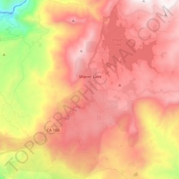
Name: Shaver Lake topographic map, elevation, terrain.
Average elevation: 1,437 m
Minimum elevation: 433 m
Maximum elevation: 2,096 m
Make a donation
Gear up for your next adventure:
As an Amazon Associate, this site earns from qualifying purchases at no extra cost to you.
Other topographic maps
Click on a map to view its topography, its elevation and its terrain.
Indio
United States > California > Riverside County
Indio is home of Riverside County's eastern administration offices. Palm Springs had more people from 1955 to 1992, when the US census announced that Indio surpassed Palm Springs and that title was returned to them. The official elevation of Indio is below sea level; the city hall is 14 feet (4 m) below sea…
Average elevation: 74 m
Lake Tahoe
United States > California > Placer County
Lake Tahoe has a dry-summer continental climate (Dsb in the Köppen climate classification), featuring warm, dry summers and chilly winters with regular snowfall. Mean annual precipitation ranges from over 55 inches (1,400 mm) for watersheds on the west side of the basin to about 26 inches (660 mm) near the…
Average elevation: 2,077 m
Make a donation
Gear up for your next adventure:
As an Amazon Associate, this site earns from qualifying purchases at no extra cost to you.
San Gorgonio Mountain
United States > California > San Bernardino County
Since it is the highest point in a region which is separated from higher peaks (e.g. in the Sierra Nevada) by relatively low terrain, San Gorgonio Mountain is one of the most topographically prominent peaks in the United States. It is ranked 7th among peaks in the 48 contiguous states and 18th overall.
Average elevation: 3,154 m
Santa Rosa and San Jacinto Mountains National Monument
United States > California > Riverside County
The differences in elevation, temperature, and moisture give rise to diverse vegetation. Being the western boundary of the Sonoran Desert, the eastern mountainslopes are hotter and drier, while the western side is affected by the Pacific Ocean and receives more precipitation with cooler temperatures. There are…
Average elevation: 900 m
Palm Springs
United States > California > Riverside County
One possible origin of palm in the place name comes from early Spanish explorers who referred to the area as La Palma de la Mano de Dios or "The Palm of God's hand". The earliest use of the name "Palm Springs" is from United States Topographical Engineers who used the term in 1853 maps. According to William…
Average elevation: 859 m
Make a donation
Gear up for your next adventure:
As an Amazon Associate, this site earns from qualifying purchases at no extra cost to you.
Kings Canyon National Park
United States > California > Fresno County
Kings Canyon is characterized by some of the steepest vertical relief in North America, with numerous peaks over 14,000 feet (4,300 m) on the Sierra Crest along the park's eastern border, falling to 4,500 feet (1,400 m) in the valley floor of Cedar Grove just ten miles (16 km) to the west. The Sierran crest…
Average elevation: 2,591 m
Montara
United States > California > San Mateo County
The rare and endangered species Hickman's potentilla occurs at the northern extremity of Montara on the slopes above Martini Creek at elevations ranging from 32 to 410 ft (9.8 to 125.0 m).
Average elevation: 66 m
Make a donation
Gear up for your next adventure:
As an Amazon Associate, this site earns from qualifying purchases at no extra cost to you.
Stanislaus County
There are a number or rare and endangered species found in Stanislaus County. The Beaked Clarkia, (Clarkia rostrata), is listed as a candidate for the Federal Endangered Species List. It has only been found in blue oak-gray pine associations in the foothills of the Sierra Nevada, a habitat which occurs at…
Average elevation: 151 m
Make a donation
Gear up for your next adventure:
As an Amazon Associate, this site earns from qualifying purchases at no extra cost to you.
Make a donation
Gear up for your next adventure:
As an Amazon Associate, this site earns from qualifying purchases at no extra cost to you.
Make a donation
Gear up for your next adventure:
As an Amazon Associate, this site earns from qualifying purchases at no extra cost to you.
Camarillo
United States > California > Ventura County
In the mid-1950s, the Ventura Freeway was completed from Los Angeles to points north, making it an easy one-hour trip to Camarillo. The Old Town was bisect by the Ventura Freeway. On the southern side of the freeway contains a strip of businesses, churches, schools, and parks. The freeway was originally…
Average elevation: 90 m
Desert Hot Springs
United States > California > Riverside County
Summer winds and the higher elevation keep Desert Hot Springs on average 5-7 degrees cooler than other communities in Coachella Valley. However, the winter season can be warmer due to the surrounding mountains blocking north winds. Since it lies at a higher elevation than the cities further south, cold air…
Average elevation: 498 m
Inyo County
Mount Whitney, the highest peak in the contiguous United States, is on Inyo County's western border (with Tulare County). The Badwater Basin in Death Valley National Park, the lowest place in North America, is in eastern Inyo County. The difference between the two points is about 14,700 feet (4,500 m). They…
Average elevation: 1,473 m
Make a donation
Gear up for your next adventure:
As an Amazon Associate, this site earns from qualifying purchases at no extra cost to you.
Make a donation
Gear up for your next adventure:
As an Amazon Associate, this site earns from qualifying purchases at no extra cost to you.
Make a donation
Gear up for your next adventure:
As an Amazon Associate, this site earns from qualifying purchases at no extra cost to you.
Downieville
United States > California > Sierra County
Downieville is a census-designated place in and the county seat of Sierra County, California, United States. Downieville is on the North Fork of the Yuba River, at an elevation of 2,966 feet (904 m). The 2020 United States census reported Downieville's population was 290.
Average elevation: 1,157 m
Make a donation
Gear up for your next adventure:
As an Amazon Associate, this site earns from qualifying purchases at no extra cost to you.
Jasmine Glen Estates
United States > California > Ventura County > Simi Valley
Average elevation: 331 m
Coleville
United States > California > Mono County
Coleville is an unincorporated community and census-designated place (CDP) in Mono County, California, United States. It is located at an elevation of 5,141 feet (1,567 m) in the Antelope Valley on the West Walker River. The population was 419 at the 2020 census, down from 495 at the 2010 census.
Average elevation: 1,683 m
Make a donation
Gear up for your next adventure:
As an Amazon Associate, this site earns from qualifying purchases at no extra cost to you.
Los Banos
United States > California > Merced County
Los Banos is located on the west side of the San Joaquin Valley, 26 miles (42 km) southwest of Merced, at about 118 ft (36 m) elevation. Its coordinates are 37°03′30″N 120°51′00″W / 37.05833°N 120.85000°W / 37.05833; -120.85000. The city is at the intersection of California State Route 152…
Average elevation: 36 m
Make a donation
Gear up for your next adventure:
As an Amazon Associate, this site earns from qualifying purchases at no extra cost to you.
Fort Irwin
United States > California > San Bernardino County
Fort Irwin National Training Center (Fort Irwin NTC) is a major training area for the United States military in the Mojave Desert in northern San Bernardino County, California. Fort Irwin is at an average elevation of 2,454 feet (748 m). It is located 37 miles (60 km) northeast of Barstow, in the Calico…
Average elevation: 785 m
Make a donation
Gear up for your next adventure:
As an Amazon Associate, this site earns from qualifying purchases at no extra cost to you.
Make a donation
Gear up for your next adventure:
As an Amazon Associate, this site earns from qualifying purchases at no extra cost to you.
Make a donation
Gear up for your next adventure:
As an Amazon Associate, this site earns from qualifying purchases at no extra cost to you.
Orland
United States > California > Glenn County
Orland is a city in Glenn County, California. The population as of the 2020 census was 8,298. The population was 7,291 at the 2010 census, up from 6,281 at the 2000 census, making Orland the most populous and fastest growing city in Glenn County. Orland is located 16 miles (26 km) north of Willows, at an…
Average elevation: 78 m
East Colton Heights
United States > California > San Bernardino County > Colton
Average elevation: 326 m
Goleta
United States > California > Santa Barbara County
The Goleta Valley is a coastal plain, approximately three miles (4.8 km) across, between the Santa Ynez Mountains, the principal mountain range of southern Santa Barbara County, and the Pacific Ocean. It consists of Holocene and Pleistocene alluvium, colluvium, estuarine deposits, as well as marine terraces…
Average elevation: 57 m
Make a donation
Gear up for your next adventure:
As an Amazon Associate, this site earns from qualifying purchases at no extra cost to you.
Hayfork
United States > California > Trinity County
Hayfork is located at 40°34′17″N 123°8′48″W / 40.57139°N 123.14667°W / 40.57139; -123.14667 (40.571406, -123.146619) at an elevation of 2310 feet.
Average elevation: 1,049 m
Make a donation
Gear up for your next adventure:
As an Amazon Associate, this site earns from qualifying purchases at no extra cost to you.
American River
United States > California > Sacramento County > Rancho Cordova
The North Fork is the longest tributary of the American River, at 88 miles (142 km). It begins at an elevation of about 7,900 feet (2,400 m) near Lake Tahoe in Placer County at Mountain Meadow Lake, just northeast of Granite Chief and immediately due west of Palisades Tahoe (formerly Squaw Valley) Ski Resort.…
Average elevation: 44 m
Make a donation
Gear up for your next adventure:
As an Amazon Associate, this site earns from qualifying purchases at no extra cost to you.
Make a donation
Gear up for your next adventure:
As an Amazon Associate, this site earns from qualifying purchases at no extra cost to you.
Rancho Mission Viejo Ecological Reserve
United States > California > Orange County
Average elevation: 160 m
West Menlo Park
United States > California > San Mateo County > West Menlo Park
Average elevation: 51 m
Make a donation
Gear up for your next adventure:
As an Amazon Associate, this site earns from qualifying purchases at no extra cost to you.
Make a donation
Gear up for your next adventure:
As an Amazon Associate, this site earns from qualifying purchases at no extra cost to you.
Make a donation
Gear up for your next adventure:
As an Amazon Associate, this site earns from qualifying purchases at no extra cost to you.
Colfax
United States > California > Placer County
Colfax has a hot-summer Mediterranean climate (Köppen Csa) that is characterized by cool, wet winters and hot, dry summers. Summers can be quite hot, especially in the months of July and August where temperatures easily reach 90 °F (32 °C), with plenty of sunshine. Winters, on the other hand, are quite cool…
Average elevation: 685 m
Plumas County
In 1850, African-American frontiersman James Beckwourth discovered the lowest pass through the Sierras, which became known as Beckwourth Pass. Using the pass, he blazed a trail from Western Nevada through much of Plumas County, eventually terminating in the Sacramento Valley. Many erstwhile miners followed…
Average elevation: 1,560 m
Make a donation
Gear up for your next adventure:
As an Amazon Associate, this site earns from qualifying purchases at no extra cost to you.
Deer Lake Highlands
United States > California > Los Angeles County > Unincorporated Chatsworth
Average elevation: 421 m
Make a donation
Gear up for your next adventure:
As an Amazon Associate, this site earns from qualifying purchases at no extra cost to you.
Mammoth Mountain
United States > California > Mono County > Mammoth Lakes
Mammoth Mountain is a lava dome complex in Mono County, California. It lies in the southwestern corner of the Long Valley Caldera and consists of about 12 rhyodacite and dacite overlapping domes. These domes formed in a long series of eruptions from 110,000 to 57,000 years ago, building a volcano that reaches…
Average elevation: 3,011 m
Make a donation
Gear up for your next adventure:
As an Amazon Associate, this site earns from qualifying purchases at no extra cost to you.