
Kings Canyon National Park topographic map
Interactive map
Click on the map to display elevation.
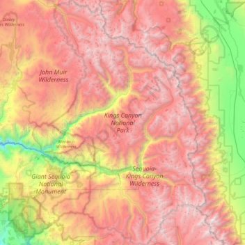
Kings Canyon National Park topographic map, elevation, terrain
Kings Canyon National Park
Kings Canyon is characterized by some of the steepest vertical relief in North America, with numerous peaks over 14,000 feet (4,300 m) on the Sierra Crest along the park's eastern border, falling to 4,500 feet (1,400 m) in the valley floor of Cedar Grove just ten miles (16 km) to the west. The Sierran crest forms the eastern boundary of the park, from Mount Goethe in the north, down to Junction Peak, at the boundary with Sequoia National Park. Several passes cross the crest into the park, including Bishop Pass, Taboose Pass, Sawmill Pass, and Kearsarge Pass. All of these passes are above 11,000 feet (3,400 m) in elevation.
About this map
Name: Kings Canyon National Park topographic map, elevation, terrain.
Average elevation: 2,591 m
Minimum elevation: 630 m
Maximum elevation: 4,372 m
Other topographic maps
Click on a map to view its topography, its elevation and its terrain.
Kingsburg
United States > California > Fresno County
Kingsburg is a city in Fresno County, California. Kingsburg is located 5 miles (8 km) southeast of Selma at an elevation of 302 feet (92 m), on the banks of the Kings River. The city is 21 miles (34 km) from Fresno, and about 130 miles (210 km) from the California Central Coast and Sierra Nevada mountain…
Average elevation: 93 m
Clovis
United States > California > Fresno County > Clovis
Clovis is a city in Fresno County, California, United States. The 2020 population was 120,124. Clovis is located 6.5 miles (10.5 km) northeast of downtown Fresno, at an elevation of 361 feet (110 m).
Average elevation: 127 m