Geolocate

Challenge topographic map

Click on the map to display elevation.

About this map

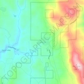
Name: Challenge topographic map, elevation, terrain.

Location: Challenge, Yuba County, California, 95925, United States (39.46590 -121.24475 39.50590 -121.20475)

Average elevation: 837 m

Minimum elevation: 695 m

Maximum elevation: 1,118 m

Gear up for your next adventure:

🦶Anti-Blister Balm - Prevents friction and hotspots during long ascents
🦯Trekking Poles - Reduced impact on joints for steep topographic climbs
🧴Outdoor Sunscreen - High SPF protection for high-altitude UV exposure
🥾Lightweight Hiking Shoes - Comfortable shoes for day hikes
📷Outdoor Action Camera - Capture high-elevation views and rugged adventures

As an Amazon Associate, this site earns from qualifying purchases at no extra cost to you.