
Oxnard topographic map
Click on the map to display elevation.
About this map
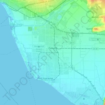
Name: Oxnard topographic map, elevation, terrain.
Location: Oxnard, Ventura County, California, United States (34.11932 -119.32922 34.26147 -119.11970)
Average elevation: 16 m
Minimum elevation: -1 m
Maximum elevation: 179 m
Other topographic maps
Click on a map to view its topography, its elevation and its terrain.
Jasmine Glen Estates
United States > California > Ventura County > Simi Valley
Average elevation: 331 m