
Shingletown topographic map
Click on the map to display elevation.
About this map
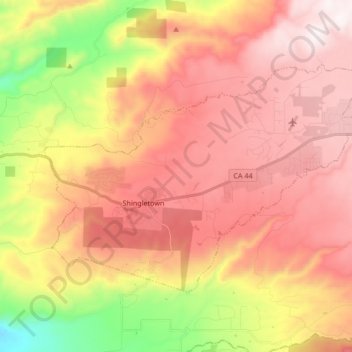
Name: Shingletown topographic map, elevation, terrain.
Average elevation: 920 m
Minimum elevation: 370 m
Maximum elevation: 1,312 m
Other topographic maps
Click on a map to view its topography, its elevation and its terrain.
Redding
United States > California > Shasta County > Redding
The elevation in Redding is 495 feet (151 meters) on average, whereas anywhere to the north, east, or west of downtown ranges between 550 feet (170 m) and 800 feet (240 m) feet. Southern portions range between 400 feet (120 m) and 500 feet (150 m).
Average elevation: 312 m