
Make a donation
Gear up for your next adventure:
As an Amazon Associate, this site earns from qualifying purchases at no extra cost to you.
Downieville topographic map
Click on the map to display elevation.
Make a donation
Gear up for your next adventure:
As an Amazon Associate, this site earns from qualifying purchases at no extra cost to you.
Downieville
Downieville is a census-designated place in and the county seat of Sierra County, California, United States. Downieville is on the North Fork of the Yuba River, at an elevation of 2,966 feet (904 m). The 2020 United States census reported Downieville's population was 290.
Make a donation
Gear up for your next adventure:
As an Amazon Associate, this site earns from qualifying purchases at no extra cost to you.
About this map
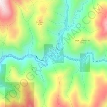
Name: Downieville topographic map, elevation, terrain.
Location: Downieville, Sierra County, California, United States (39.54044 -120.84822 39.58044 -120.80822)
Average elevation: 1,157 m
Minimum elevation: 839 m
Maximum elevation: 1,628 m
Make a donation
Gear up for your next adventure:
As an Amazon Associate, this site earns from qualifying purchases at no extra cost to you.