Geolocate

Colfax topographic map

Click on the map to display elevation.

Colfax

Colfax has a hot-summer Mediterranean climate (Köppen Csa) that is characterized by cool, wet winters and hot, dry summers. Summers can be quite hot, especially in the months of July and August where temperatures easily reach 90 °F (32 °C), with plenty of sunshine. Winters, on the other hand, are quite cool with temperatures in December hovering around 46 °F (8 °C), and owing to its altitude above sea level, Colfax some years sees snow accumulation.

Wikipedia (CC-BY-SA 3.0)

About this map

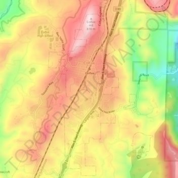
Name: Colfax topographic map, elevation, terrain.

Location: Colfax, Placer County, California, United States (39.07492 -120.96506 39.11484 -120.93491)

Average elevation: 685 m

Minimum elevation: 442 m

Maximum elevation: 860 m

Other topographic maps

Click on a map to view its topography, its elevation and its terrain.

Tahoe City

United States > California > Placer County

Average elevation: 1,977 m

Emigrant Gap

United States > California > Placer County

Average elevation: 1,563 m

Big Chief

United States > California > Placer County

Average elevation: 2,035 m

Foresthill

United States > California > Placer County

Average elevation: 749 m

Salmon Lake

United States > California > Placer County

Average elevation: 2,023 m

Gear up for your next adventure:

🚲MTB Frame Bag - Carry tools and maps directly on your bicycle frame
🧴Bear Spray Holster - Quick-access carry for essential Canadian wilderness safety
🥾Durable Hiking Shoes - Long-lasting shoes for frequent hiking
🦶Hiking Shoe Insoles - Added support for high arches and long days on feet
👖Convertible Hiking Pants - Zip-off legs to adapt to changing weather conditions

As an Amazon Associate, this site earns from qualifying purchases at no extra cost to you.