Geolocate

Curtis Mountain topographic map

Click on the map to display elevation.

About this map

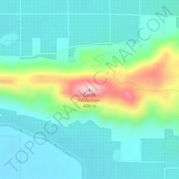
Name: Curtis Mountain topographic map, elevation, terrain.

Location: Curtis Mountain, Tulare County, California, United States (36.59462 -119.25628 36.59472 -119.25618)

Average elevation: 188 m

Minimum elevation: 124 m

Maximum elevation: 397 m

Other topographic maps

Click on a map to view its topography, its elevation and its terrain.

Visalia

United States > California > Tulare County

Average elevation: 102 m

Gear up for your next adventure:

🔭Compact Binoculars - Lightweight optics for scouting trails and wildlife
🧴Outdoor Sunscreen - High SPF protection for high-altitude UV exposure
🥾Light Trekking Boots - Supportive boots for multi-day treks
🛶Kayak Accessories - Essential gear for safe and fun kayaking adventures
🥾Waterproof Hiking Boots - Essential footwear for rugged terrain and wet Canadian trails

As an Amazon Associate, this site earns from qualifying purchases at no extra cost to you.