
Desert Hot Springs topographic map
Click on the map to display elevation.
Desert Hot Springs
Summer winds and the higher elevation keep Desert Hot Springs on average 5-7 degrees cooler than other communities in Coachella Valley. However, the winter season can be warmer due to the surrounding mountains blocking north winds. Since it lies at a higher elevation than the cities further south, cold air drains into the lower elevation of the Coachella Valley, which results in warmer night-time lows, producing an example of thermal inversion.
About this map
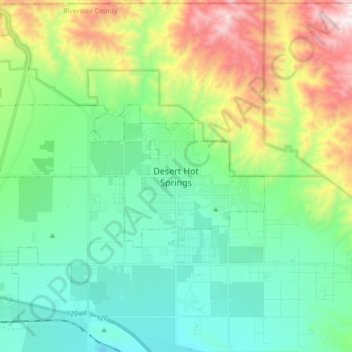
Name: Desert Hot Springs topographic map, elevation, terrain.
Average elevation: 498 m
Minimum elevation: 160 m
Maximum elevation: 1,366 m
Other topographic maps
Click on a map to view its topography, its elevation and its terrain.
Colorado River
United States > California > Riverside County
The entire eastern boundary of the Colorado River Basin runs along the North American Continental Divide and is defined largely by the Rocky Mountains and the Rio Grande Basin. The Wind River Range in Wyoming marks the northern extent of the basin, and is separated from the Colorado Rockies by the endorheic…
Average elevation: 93 m
Idyllwild-Pine Cove
United States > California > Riverside County
"Mile-high Idyllwild" is a mountain resort about one-mile (1,600 m) in altitude. Idyllwild is flanked by two large rock formations, Tahquitz Peak and Suicide Rock (also known as Lily Rock), which are famous in Southern California rock-climbing circles. It offers no skiing, so "the Hill" has been minimally…
Average elevation: 1,746 m