Geolocate

Woodson Mountain topographic map

Interactive map

Click on the map to display elevation.

Woodson Mountain topographic map, elevation, terrain

Woodson Mountain topographic map, elevation, terrain

About this map

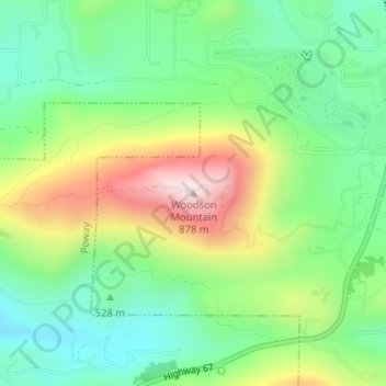
Name: Woodson Mountain topographic map, elevation, terrain.

Location: Woodson Mountain, San Diego County, California, United States (33.00863 -116.97077 33.00873 -116.97067)

Average elevation: 560 m

Minimum elevation: 385 m

Maximum elevation: 868 m

Other topographic maps

Click on a map to view its topography, its elevation and its terrain.

El Cajon

United States > California > San Diego County

Average elevation: 178 m

Del Mar

United States > California > San Diego County

Average elevation: 24 m

San Marcos

United States > California > San Diego County

Average elevation: 219 m

Poway

United States > California > San Diego County

Average elevation: 275 m

San Diego

United States > California > San Diego County

The climate in San Diego, like most of Southern California, often varies significantly over short geographical distances, resulting in microclimates. In San Diego, this is mostly because of the city's topography (the Bay, and the numerous hills, mountains, and canyons). Frequently, particularly during the "May…

Average elevation: 125 m

Bonita

United States > California > San Diego County

Average elevation: 95 m

Escondido

United States > California > San Diego County

Escondido has a borderline semi-arid climate (Köppen: Bsh) and hot-summer Mediterranean climate (Köppen: Csa) with hot summers and cool wet winters. Owing to its inland setting it is considerably warmer than coastal cities like San Diego, Carlsbad or Oceanside during the summertime, and cooler in the winter.…

Average elevation: 273 m

Cree

United States > California > San Diego County > Poway > Ipai Waaypuk

Average elevation: 179 m