Geolocate

Panglao topographic map

Click on the map to display elevation.

About this map

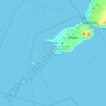
Name: Panglao topographic map, elevation, terrain.

Location: Panglao, Bohol, Central Visayas, 6340, Philippines (9.38861 123.55673 9.70833 123.85980)

Average elevation: 4 m

Minimum elevation: -1 m

Maximum elevation: 185 m

Gear up for your next adventure:

🐕Hiking Dog Pack - Let your canine companion carry their own water and food
🥾Trail Running Shoes - Lightweight and durable shoes for trail running
🧊Insulated Water Bottle - Keeps drinks cold in summer and prevents freezing in winter
🧭GPS Tracker - Track your location in remote areas safely
🥾Trail Hiking Boots - Supportive boots for rough trails

As an Amazon Associate, this site earns from qualifying purchases at no extra cost to you.