Geolocate

Panglao topographic map

Click on the map to display elevation.

About this map

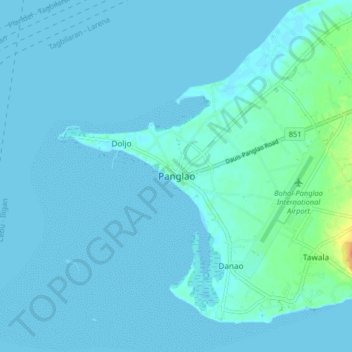
Name: Panglao topographic map, elevation, terrain.

Location: Panglao, Bohol, Central Visayas, 6340, Philippines (9.53912 123.70516 9.61912 123.78516)

Average elevation: 4 m

Minimum elevation: -1 m

Maximum elevation: 39 m

Other topographic maps

Click on a map to view its topography, its elevation and its terrain.

Bolod

Philippines > Bohol > Panglao

Average elevation: 22 m

Tawala

Philippines > Bohol > Panglao

Average elevation: 17 m

Bil-isan

Philippines > Bohol > Panglao

Average elevation: 6 m

Tawala

Philippines > Bohol > Panglao

Average elevation: 17 m

Alona Beach

Philippines > Bohol > Panglao > Tawala

Average elevation: 6 m

Libaong

Philippines > Bohol > Panglao

Average elevation: 23 m

Doljo Beach

Philippines > Bohol > Panglao

Average elevation: 1 m

Dumaluan

Philippines > Bohol > Panglao > Libaong

Average elevation: 10 m

Gear up for your next adventure:

💧Hydration Bladder - Hands-free hydration solution for long treks
🦯Trekking Poles - Reduced impact on joints for steep topographic climbs
💡Portable Camping Lamp - Rechargeable lamp for campsite lighting
🧥Ultralight Puffy Jacket - Maximum warmth that packs down to the size of an orange
Bushcraft Tarp - Versatile emergency shelter or gear protection

As an Amazon Associate, this site earns from qualifying purchases at no extra cost to you.