
Seyhan topographic map
Interactive map
Click on the map to display elevation.
About this map
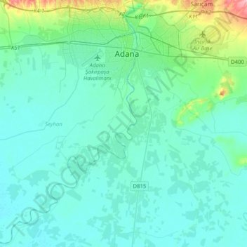
Name: Seyhan topographic map, elevation, terrain.
Location: Seyhan, Adana, Mediterranean Region, Turkey (36.79083 35.08813 37.04000 35.33834)
Average elevation: 23 m
Minimum elevation: 3 m
Maximum elevation: 153 m
Other topographic maps
Click on a map to view its topography, its elevation and its terrain.
Gaziantep
The plan introduced several important changes to the city's transportation network. One of the most important was the addition of a rail line to connect Gaziantep to the national rail system. Up to now, Turkish railway construction had ignored Gaziantep (partly because of its mountainous surroundings); a…
Average elevation: 880 m
Marmaraereğlisi
Turkey > Marmaraereğlisi > Cedit Ali Paşa Mahallesi > Marmaraereğlisi
Average elevation: 12 m
Mihalıççık
Turkey > Mihalıççık > Mihalıççık
Mihalıççık, also Mihalıçcık (English: Micalizo, sometimes Mihaliccik), is a town and district of Eskişehir Province in the Central Anatolia region of Turkey. According to 2010 census, population of the district is 10,482 of which 3,133 live in the town of Mihalıççık. The district covers an area of…
Average elevation: 1,284 m
Archaeological Site of Troy
Turkey > Canakkale > Tevfikiye
The fact that the topography around the site matches the topographic detail of the poem gives to the poem a life-like quality not equaled by other epics. In the Iliad, the Achaeans set up their camp near the mouth of the River Scamander (modern Karamenderes), where they beached their ships. The city of Troy…
Average elevation: 19 m
Kadifekale
Kadifekale (literally "the velvet castle" in Turkish) is a hilltop castle in İzmir, Turkey. The castle is located on the Mount Pagos (Greek: Πάγος, Pagus under the Roman Empire) which has an elevation of 186 metres. It was built in the 3rd century BC. The castle is located at a distance of about 2 km…
Average elevation: 65 m