
Valdieri topographic map
Click on the map to display elevation.
About this map
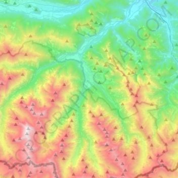
Name: Valdieri topographic map, elevation, terrain.
Location: Valdieri, Cuneo, Piemonte, Italia (44.14077 7.18838 44.30868 7.45273)
Average elevation: 1,584 m
Minimum elevation: 623 m
Maximum elevation: 3,275 m
Other topographic maps
Click on a map to view its topography, its elevation and its terrain.
Rifugio Mondovì - Havis De Giorgio
Italia > Piemonte > Cuneo > Roccaforte Mondovì
Il rifugio Havis De Giorgio - Mondovì (a volte indicato semplicemente come rifugio Mondovì) è un rifugio situato nella catena delle Alpi Liguri nel comune di Roccaforte Mondovì, in provincia di Cuneo, a 1761 metri di altitudine.
Average elevation: 1,953 m
Monte Jurin
Italia > Piemonte > Cuneo > Limone Piemonte
La montagna sui trova sulla costiera che divide la Valle Vermenagna dalla Valle Pesio. Verso sud il crinale perde quota con il Colletto nord del Cros dirigendosi poi verso le Rocce del Cros e la Cima della Fascia. A nord lo spartiacque, dopo una insellatura, risale alla rocciosa Cima Baban per poi allargarsi…
Average elevation: 1,856 m
Prato Nevoso
La sua storia risale ai primi anni sessanta quando un gruppo di imprenditori liguri decise di creare una stazione invernale facilmente raggiungibile sia da Savona e Genova sia da Torino. La scelta cadde su degli alpeggi situati nel comune di Frabosa Sottana a una altitudine di oltre 1500 metri. I veloci lavori…
Average elevation: 1,436 m
Giardino Famiglia Allemandi
Italia > Piemonte > Cuneo > Villar San Costanzo > Pramallé
Average elevation: 654 m
Monviso
Italia > Piemonte > Cuneo > Pontechianale
La prima salita del Monviso è stata, tuttavia, messa in dubbio. Lo studioso francese Olivier Joseph ha infatti dimostrato che la cima del monte è stata molto probabilmente raggiunta oltre un secolo prima della tanto decantata salita di William Matthews, nel corso delle operazioni topografiche di rilevamento…
Average elevation: 2,985 m
Valmala
Italia > Piemonte > Cuneo > Busca
Il territorio di Valmala è situato in Valle Varaita, provincia di Cuneo, e la sua altitudine è compresa tra i circa 800 m s.l.m. e i 1625 m s.l.m. della cima del Monte San Bernardo. Esso si sviluppa lungo una stretta valle laterale che nasce sulla destra orografica della Valle Varaita ed è caratterizzato da…
Average elevation: 995 m