Geolocate

Borgata Calchesio topographic map

Click on the map to display elevation.

About this map

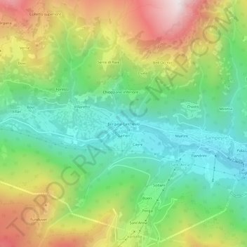
Name: Borgata Calchesio topographic map, elevation, terrain.

Location: Borgata Calchesio, Sampeyre, Cuneo, Piemonte, Italia (44.56190 7.14774 44.60190 7.18774)

Average elevation: 1,369 m

Minimum elevation: 922 m

Maximum elevation: 2,095 m

Other topographic maps

Click on a map to view its topography, its elevation and its terrain.

Lago di Luca

Italia > Piemonte > Cuneo > Sampeyre

Average elevation: 2,342 m

Gear up for your next adventure:

🎒Backpack Rain Cover - External shield to keep your entire pack dry
🦯Trekking Poles - Reduced impact on joints for steep topographic climbs
🧰Survival Kit - Essential gear for emergencies in the wilderness
Bushcraft Tarp - Versatile emergency shelter or gear protection
🧊Insulated Water Bottle - Keeps drinks cold in summer and prevents freezing in winter

As an Amazon Associate, this site earns from qualifying purchases at no extra cost to you.