Geolocate

Friddia topographic map

Click on the map to display elevation.

About this map

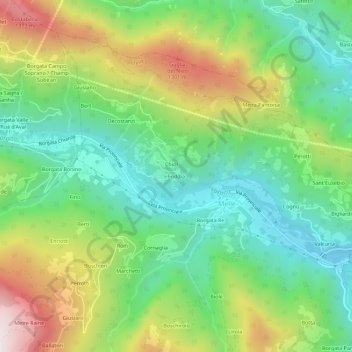
Name: Friddia topographic map, elevation, terrain.

Location: Friddia, Melle, Cuneo, Piemonte, Italia (44.54516 7.29241 44.58516 7.33241)

Average elevation: 933 m

Minimum elevation: 628 m

Maximum elevation: 1,468 m

Gear up for your next adventure:

💧Hydration Bladder - Hands-free hydration solution for long treks
🔭Outdoor Binoculars - Lightweight binoculars for birdwatching and hiking
🦌Outdoor Trail Camera - Monitor wildlife activity near your favorite spots
🧦Outdoor Socks - Durable socks designed for hiking and outdoor sports
🥾Trail Hiking Boots - Supportive boots for rough trails

As an Amazon Associate, this site earns from qualifying purchases at no extra cost to you.