Geolocate

Raso topographic map

Click on the map to display elevation.

About this map

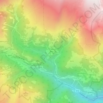
Name: Raso topographic map, elevation, terrain.

Location: Raso, Ostana, Cuneo, Piemonte, Italia (44.68277 7.15516 44.72277 7.19516)

Average elevation: 1,595 m

Minimum elevation: 932 m

Maximum elevation: 2,317 m

Gear up for your next adventure:

💧Filtered Water Bottle - Safe drinking water on the go
🧭GPS Tracker - Track your location in remote areas safely
🧥Waterproof Pants - Keep dry during rainy hiking conditions
🧢Hiking Hat - Sun-protective and breathable hats for long treks
🧭GPS Handheld Device - Reliable GPS navigation for outdoor adventures

As an Amazon Associate, this site earns from qualifying purchases at no extra cost to you.