Geolocate

Punta Parvo topographic map

Click on the map to display elevation.

About this map

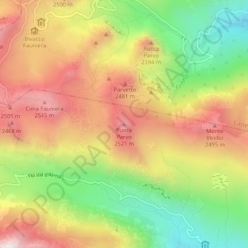
Name: Punta Parvo topographic map, elevation, terrain.

Location: Punta Parvo, Demonte, Cuneo, Piemonte, Italia (44.38355 7.13962 44.38365 7.13972)

Average elevation: 2,219 m

Minimum elevation: 1,819 m

Maximum elevation: 2,602 m

Gear up for your next adventure:

🥾Light Trekking Boots - Supportive boots for multi-day treks
🏕️Camping Hammock - Integrated protection for sleeping between trees
🥾Waterproof Hiking Shoes - Durable shoes for wet and rugged trails
🔋Emergency Crank Radio - Weather alerts and power without needing batteries
🚲Heavy Duty Bike Lock - Secure your bike at the trailhead or during stops

As an Amazon Associate, this site earns from qualifying purchases at no extra cost to you.